IMAGES TAKEN NEAR TO
Cane Lane, WANTAGE, OX12 0AA
Introduction
This page details the photographs taken nearby to Cane Lane, OX12 0AA by members of the Geograph project.
The Geograph project started in 2005 with the aim of publishing, organising and preserving representative images for every square kilometre of Great Britain, Ireland and the Isle of Man.

There are currently over 7.5m images from over14,400 individuals and you can help contribute to the project by visiting https://www.geograph.org.uk
Image Map
Images are licensed for reuse under creativecommons.org/licenses/by-sa/2.0
Notes
- Clicking on the map will re-center to the selected point.
- The higher the marker number, the further away the image location is from the centre of the postcode.
Image Listing (18 Images Found)
Images are licensed for reuse under creativecommons.org/licenses/by-sa/2.0
Image
Details
Distance
1
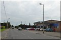
Grove Car Sales, Main Street
At some stage this was a filling station for Q8 fuels
Image: © David Smith
Taken: 9 Jun 2018
0.05 miles
2
Bus shelter at the south end of Main Street, Grove
Image: © David Smith
Taken: 9 Jun 2018
0.06 miles
3
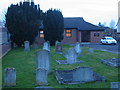
Strict Baptist Chapel, Grove
The Strict Baptist Chapel and graveyard, to be found on Main Street, Grove.
Image: © Simon Atkin
Taken: 28 Mar 2006
0.09 miles
4
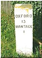
Old Milestone by the A338 in Grove, north of Wantage
Carved stone post by the A338, in parish of Grove (Vale of White Horse District), Station Road; Grove Canal Bridge Turn at junction. with Main Street, on grass in front of wooden fence at apex of junction, on West side of road. Vale square, erected by the Besselsleigh turnpike trust in the 19th century.
Inscription reads:-
OXFORD
13
WANTAGE
1
Grade II listed.
List Entry Number: 1048156 https://historicengland.org.uk/listing/the-list/list-entry/1048156
Milestone Society National ID: BE_WABL01
Image: © A Rosevear
Taken: 3 Aug 2004
0.10 miles
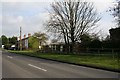
5
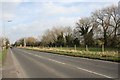
A338 past the canal
The A338 going past the field that marks Wilts and Berks canal
Image: © Bill Nicholls
Taken: 1 Mar 2009
0.11 miles
6
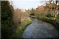
Letcombe Brook
At least I think that is what it is called, flows through Wantage and comes out here.
Image: © Bill Nicholls
Taken: 1 Mar 2009
0.13 miles
7
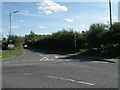
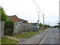
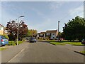
Cane Lane, Grove
Looking east from junction with Brereton Drive.In north half of grid square.
Image: © Alec Samler
Taken: 24 Sep 2004
0.15 miles
8
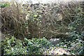
Aqueduct in the bushes
If you look carefully you can make out a wall in the shrubbery that is what remains of an aqueduct that took the Wilts and Berks canal across Letcombe brook.
Image: © Bill Nicholls
Taken: 1 Mar 2009
0.16 miles
9
Laurel Crescent, Grove
A road off Main Street.
Image: © Oscar Taylor
Taken: 9 Oct 2023
0.16 miles
10
Back to front
The cottages in the distance are facing the old canal and were canal workers cottages. The A338 runs past what was the back and is also built on the old tramway that went from Grove station to Wantage.
Image: © Bill Nicholls
Taken: 1 Mar 2009
0.19 miles