IMAGES TAKEN NEAR TO
Thames Street, OXFORD, OX1 1EQ
Introduction
This page details the photographs taken nearby to Thames Street, OX1 1EQ by members of the Geograph project.
The Geograph project started in 2005 with the aim of publishing, organising and preserving representative images for every square kilometre of Great Britain, Ireland and the Isle of Man.

There are currently over 7.5m images from over14,400 individuals and you can help contribute to the project by visiting https://www.geograph.org.uk
Image Map (Loading...)


Getting Data...Please wait
Leaflet Map data © OpenStreetMap
Images are licensed for reuse under creativecommons.org/licenses/by-sa/2.0
Notes
- Clicking on the map will re-center to the selected point.
- The higher the marker number, the further away the image location is from the centre of the postcode.
Image Listing (898 Images Found)
Images are licensed for reuse under creativecommons.org/licenses/by-sa/2.0
Image
Details
Distance
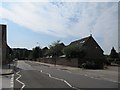
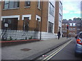
1
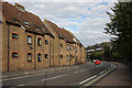
Thames Street
The A420. Interesting little roof lights on the housing, which fronts onto Cromwell Street.
Image: © Martin Addison
Taken: 11 Aug 2010
0.01 miles
2
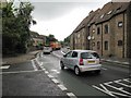
Thames Street
Thames Street, Oxford, a very busy road most times of the day. This was another road that was one way until it was changed to two way.
Image: © Bill Nicholls
Taken: 8 Jul 2009
0.01 miles
3
Shirelake Close
This area was just a wasteland when I first came to work in Oxford back in 1972. Soon after they started to build a hotel which would have been called the Churchill Hotel. Unfortunately after getting some of the concrete piles done and the ground floor started the company went bust and work stopped. For years you could see the concrete pillars standing starkly alone. Eventually the whole lot was developed into what you see now.
Image: © Bill Nicholls
Taken: 8 Jul 2009
0.02 miles
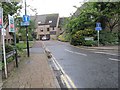
5
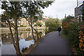
View up Thames Street
Looking up Thames Street towards St Aldate's.
Image: © Bill Nicholls
Taken: 30 Jun 2009
0.03 miles
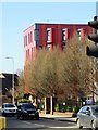
6
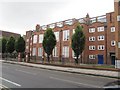
It was a school
Another place that changed over the years, it used to be a school and I remember the kids playing in the front yard now I could not tell you what it's used for, I did think housing but more likely office space.
Image: © Bill Nicholls
Taken: 8 Jul 2009
0.03 miles
7
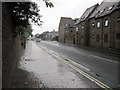
Starting to rain
Just after leaving Shirelake Close it started to rain as you can see from the photo of Thames Street. Within minutes it was looking like Image
Image: © Bill Nicholls
Taken: 8 Jul 2009
0.03 miles
8
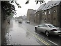
Chucking it down
Minutes after taking Image the scene looked like this.
Image: © Bill Nicholls
Taken: 8 Jul 2009
0.04 miles
10
Thames Street at junction of St Aldate's
Image: © David Howard
Taken: 29 Jun 2011
0.04 miles