IMAGES TAKEN NEAR TO
New Road, DIDCOT, OX11 9LB
Introduction
This page details the photographs taken nearby to New Road, OX11 9LB by members of the Geograph project.
The Geograph project started in 2005 with the aim of publishing, organising and preserving representative images for every square kilometre of Great Britain, Ireland and the Isle of Man.

There are currently over 7.5m images from over14,400 individuals and you can help contribute to the project by visiting https://www.geograph.org.uk
Image Map (Loading...)


Getting Data...Please wait
Leaflet Map data © OpenStreetMap
Images are licensed for reuse under creativecommons.org/licenses/by-sa/2.0
Notes
- Clicking on the map will re-center to the selected point.
- The higher the marker number, the further away the image location is from the centre of the postcode.
Image Listing (48 Images Found)
Images are licensed for reuse under creativecommons.org/licenses/by-sa/2.0
Image
Details
Distance
1
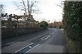
Bend to New Road
New road East Hagbourne looking towards Didcot
Image: © Bill Nicholls
Taken: 24 Jan 2010
0.02 miles
2
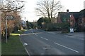
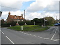
New Road past the Garage
Looking down New Road East Hagbourne towards the triangle which is round the corner in the distance.
Image: © Bill Nicholls
Taken: 24 Jan 2010
0.03 miles
3

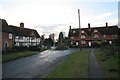
Great Mead
Small residential lane which becomes a bridleway leading to Fulscote Manor
Image: © Bill Nicholls
Taken: 24 Jan 2010
0.03 miles
4
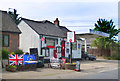
Flags by the Shop
May 8th 2020 celebrated 75 years of peace in most of Europe following the end of WW2. Some people marked the occasion privately, as shown here, but the restrictions imposed during the coronavirus outbreak meant that commemorative events had to be kept low key.
Image: © Des Blenkinsopp
Taken: 9 May 2020
0.03 miles
5

Garage on New Road
Hagbourne garage along New Road, used to sell petrol but with Sainsbury's and Tesco up the road a short way it soon declined. Now sells cars and does car repairs
Image: © Bill Nicholls
Taken: 24 Jan 2010
0.04 miles
6
Looking towards the cross
Looking towards Upper Cross, East Hagbourne.
Image: © Bill Nicholls
Taken: 24 Jan 2010
0.06 miles
7
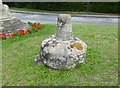
Old Wayside Cross by the B4016, Main Road, East Hagbourne
Lower Cross, old base and stump of shaft by the B4016, in parish of East Hagbourne (South Oxfordshire District), Main Road, junction with Blewbury Road, on cut grass triangle beside war memorial.
Grade II listed.
List Entry Number: 1368789 https://historicengland.org.uk/listing/the-list/list-entry/1368789
Surveyed
Milestone Society National ID: OXSO_EHA01
Image: © Alan Rosevear
Taken: 23 Aug 2013
0.07 miles
8
War memorial at the road junction in East Hagbourne
Image: © Sarah Charlesworth
Taken: 19 Feb 2010
0.07 miles
9
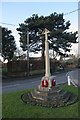
Memorial on the green
East Hagbourne village war memorial on the triangle junction by Main Road
Image: © Bill Nicholls
Taken: 24 Jan 2010
0.07 miles
10

Memorial on the green
The village war memorial on the green at East Hagbourne. Behind can be seen what looks like the old village cross.
Image: © Bill Nicholls
Taken: 24 Jan 2010
0.07 miles