IMAGES TAKEN NEAR TO
Alisons Lane, DIDCOT, OX11 9GW
Introduction
This page details the photographs taken nearby to Alisons Lane, OX11 9GW by members of the Geograph project.
The Geograph project started in 2005 with the aim of publishing, organising and preserving representative images for every square kilometre of Great Britain, Ireland and the Isle of Man.

There are currently over 7.5m images from over14,400 individuals and you can help contribute to the project by visiting https://www.geograph.org.uk
Image Map (Loading...)


Getting Data...Please wait
Leaflet Map data © OpenStreetMap
Images are licensed for reuse under creativecommons.org/licenses/by-sa/2.0
Notes
- Clicking on the map will re-center to the selected point.
- The higher the marker number, the further away the image location is from the centre of the postcode.
Image Listing (65 Images Found)
Images are licensed for reuse under creativecommons.org/licenses/by-sa/2.0
Image
Details
Distance
1
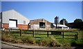
Upthorpe Farm
The fairly unattractive buildings of Upthorpe Farm in the middle of the village.
Or in Aston Tirrold to be exact, Aston Upthorpe being on the other side of the road.
Image: © Des Blenkinsopp
Taken: 24 Jul 2012
0.02 miles
2
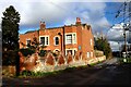
The Red House, Moreton Road, Aston Upthorpe
The blue plaque states that this was the home of Sir Patrick Abercrombie the "Pioneer of town and country planning" from 1945-1957.
Image: © David Kemp
Taken: 16 Feb 2024
0.06 miles
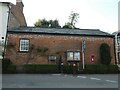
3
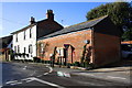
The White House, Fullers Road at The Croft junction
There was an OS benchmark at the junction of the white house with the brick extension. There is a closeup of the post box at Image
Image: © Roger Templeman
Taken: 1 Feb 2014
0.09 miles
4

Benchmark on #8 The Croft
Ordnance Survey cut mark benchmark described on the Bench Mark Database at http://www.bench-marks.org.uk/bm23778
Image: © Roger Templeman
Taken: 1 Feb 2014
0.10 miles
5

A pair of semis on The Croft
There is an OS benchmark Image on the front right corner of the right hand house behind the stacked door units
Image: © Roger Templeman
Taken: 1 Feb 2014
0.10 miles
6
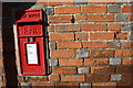
Post box and possible benchmark, Fullers Road
The arrow and horizontal bar cut in a brick to the right of the Eii2 post box are probably not the Ordnance Survey cut mark benchmark described on the Bench Mark Database at http://www.bench-marks.org.uk/bm23253
Image: © Roger Templeman
Taken: 1 Feb 2014
0.10 miles
8
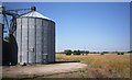
Silo Path
There is a public footpath going past the end here and off between the trees in the distance. Hard going at the moment with rapeseed plants sprawling all over it.
Image: © Des Blenkinsopp
Taken: 24 Jul 2012
0.11 miles
9
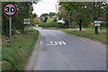
A parish boundary along the middle of Moreton Road
Aston Upthorpe is on the west (right) side of the road, Aston Tirrold on the east side. The two parishes have a combined Parish Council.
Image: © Roger Templeman
Taken: 10 Oct 2011
0.12 miles
10
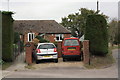
A bungalow named 'Mizpah', Moreton Road
Image: © Roger Templeman
Taken: 10 Oct 2011
0.13 miles