IMAGES TAKEN NEAR TO
Franklin Gardens, OX11 9GS
Introduction
This page details the photographs taken nearby to Franklin Gardens, OX11 9GS by members of the Geograph project.
The Geograph project started in 2005 with the aim of publishing, organising and preserving representative images for every square kilometre of Great Britain, Ireland and the Isle of Man.

There are currently over 7.5m images from over14,400 individuals and you can help contribute to the project by visiting https://www.geograph.org.uk
Image Map (Loading...)


Getting Data...Please wait
Leaflet Map data © OpenStreetMap
Images are licensed for reuse under creativecommons.org/licenses/by-sa/2.0
Notes
- Clicking on the map will re-center to the selected point.
- The higher the marker number, the further away the image location is from the centre of the postcode.
Image Listing (13 Images Found)
Images are licensed for reuse under creativecommons.org/licenses/by-sa/2.0
Image
Details
Distance
1
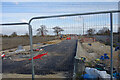
Road into the Building Site
A large new development site stretching between the Didcot ring road and the Appleford road over a kilometre away. The roofs of new houses at the far end of the site are visible on the horizon.
Image: © Des Blenkinsopp
Taken: 12 Feb 2021
0.03 miles
2
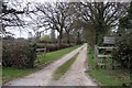
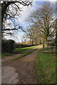
Path heading to Ladygrove Farm
Path by tree line heading to Ladygrove Farm
Image: © Shaun Ferguson
Taken: 14 Sep 2017
0.08 miles
3
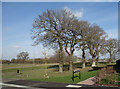
These Trees Have Survived
Now part of a large new housing estate, this was all fields until recently as can be seen in the background. These trees were no doubt once along a hedgerow and have been retained, presumably because they look nice.
Image: © Des Blenkinsopp
Taken: 12 Feb 2021
0.08 miles
4
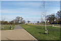
View along Franklin Gardens
What will be the main road through a large area of new housing north of the Didcot ring road.
Like elsewhere in new Didcot, generous cycle tracks have been provided.
Image: © Des Blenkinsopp
Taken: 12 Feb 2021
0.09 miles
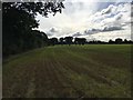
5

Six Trees
For the time being, still corralled in behind the by-pass, ever expanding Didcot hasn't yet spilled over into these fields.
Image: © Des Blenkinsopp
Taken: 19 Jan 2012
0.09 miles
6

New Housing, Franklin Gardens
Didcot just keeps on growing. New development north of the ring road.
Image: © Des Blenkinsopp
Taken: 12 Feb 2021
0.11 miles
7
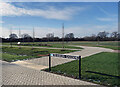
New bit of park, Franklin Gardens
A semi-circle of open space has been laid out along the west side of the brand new road called Franklin Gardens. I don't know if that's the name of the park as well.
No doubt part of the landscaping and amenity provisions now required from developers by the planners on new housing sites.
Image: © Des Blenkinsopp
Taken: 12 Feb 2021
0.12 miles
8
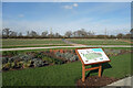
Franklin Gardens Neighbourhood Park
Another view of the new park which has been laid out adjacent to a large new housing development.
Still looking a bit bleak at the moment, but give it a couple of years and I guess it will have grown up quite nicely.
Image: © Des Blenkinsopp
Taken: 12 Feb 2021
0.14 miles
9
Entrance to Ladygrove Farm from B4016
Some of the cooling towers of Didcot A Power Station are visible through the trees.
Image: © Roger Templeman
Taken: 8 Mar 2012
0.20 miles