IMAGES TAKEN NEAR TO
Aston Upthorpe, DIDCOT, OX11 9EF
Introduction
This page details the photographs taken nearby to OX11 9EF by members of the Geograph project.
The Geograph project started in 2005 with the aim of publishing, organising and preserving representative images for every square kilometre of Great Britain, Ireland and the Isle of Man.

There are currently over 7.5m images from over14,400 individuals and you can help contribute to the project by visiting https://www.geograph.org.uk
Image Map (Loading...)


Getting Data...Please wait
Leaflet Map data © OpenStreetMap
Images are licensed for reuse under creativecommons.org/licenses/by-sa/2.0
Notes
- Clicking on the map will re-center to the selected point.
- The higher the marker number, the further away the image location is from the centre of the postcode.
Image Listing (108 Images Found)
Images are licensed for reuse under creativecommons.org/licenses/by-sa/2.0
Image
Details
Distance
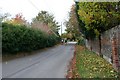
1
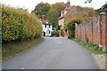
Thorpe Street
Looking up Thorpe Street towards the bend.
Image: © Bill Nicholls
Taken: 25 Oct 2009
0.03 miles
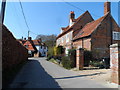
3
The northern end of Thorpe Street, Aston Upthorpe
Image: © Stuart Logan
Taken: 28 Feb 2013
0.03 miles
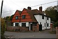
4
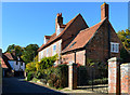
Edlins, Aston Upthorpe, Oxfordshire
Late C17 with C19 and C20 alterations. Grey brick with red brick dressings; old plain-tile roof; brick central ridge stack. 2-unit through passage plan. 2 storey and attic; 3-window range. Sash door to C20 gabled porch to centre. 16-pane unhorned sashes to left and right. Moulded brick band between ground and first floor. 12-pane sash to first floor centre. 16-pane unhorned sashes to left and right. Moulded red brick cornice to eaves. 2 gabled dormers with 2-light wood casements. Left return: wood casement to ground floor. Moulded brick band between ground and first floor. Blind rendered panel to first floor centre. Moulded brick band between first floor and attic gable. 2-light C20 casement to attic gable. Outshut to rear with cross-gabled projection to centre with 2-light mullion and transom stair window with 3 transoms.
(Source:Historic England)
Image: © Oswald Bertram
Taken: 9 Oct 2015
0.03 miles
5
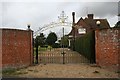
Gates on the street
Thought these gates were worth a photo along Thorpe Street.
Image: © Bill Nicholls
Taken: 25 Oct 2009
0.03 miles
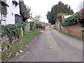
6
Riding to Didcot
Couple of cyclists riding along the road out of Aston Upthorpe towards Didcot.
Image: © Bill Nicholls
Taken: 25 Oct 2009
0.04 miles
7
House on the corner
Might be a pair of them but it's on the corner of Thorpe Street.
Image: © Bill Nicholls
Taken: 25 Oct 2009
0.06 miles
8
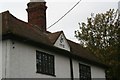
JM 1912
Well it looks like the original owner had their initials put in the roof for posterity
Image: © Bill Nicholls
Taken: 25 Oct 2009
0.06 miles
9
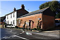
The White House, Fullers Road at The Croft junction
There was an OS benchmark at the junction of the white house with the brick extension. There is a closeup of the post box at Image
Image: © Roger Templeman
Taken: 1 Feb 2014
0.07 miles
10
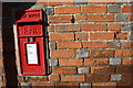
Post box and possible benchmark, Fullers Road
The arrow and horizontal bar cut in a brick to the right of the Eii2 post box are probably not the Ordnance Survey cut mark benchmark described on the Bench Mark Database at http://www.bench-marks.org.uk/bm23253
Image: © Roger Templeman
Taken: 1 Feb 2014
0.07 miles