IMAGES TAKEN NEAR TO
Didcot Road, DIDCOT, OX11 9ED
Introduction
This page details the photographs taken nearby to Didcot Road, OX11 9ED by members of the Geograph project.
The Geograph project started in 2005 with the aim of publishing, organising and preserving representative images for every square kilometre of Great Britain, Ireland and the Isle of Man.

There are currently over 7.5m images from over14,400 individuals and you can help contribute to the project by visiting https://www.geograph.org.uk
Image Map (Loading...)


Getting Data...Please wait
Leaflet Map data © OpenStreetMap
Images are licensed for reuse under creativecommons.org/licenses/by-sa/2.0
Notes
- Clicking on the map will re-center to the selected point.
- The higher the marker number, the further away the image location is from the centre of the postcode.
Image Listing (10 Images Found)
Images are licensed for reuse under creativecommons.org/licenses/by-sa/2.0
Image
Details
Distance
1
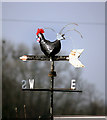
A Real Weathercock
People call these things weathercocks but they often tend to feature a fairly random selection of non-poultry subjects.
It's frequently horses round here.
This one's the real deal though.
It's in this garden near Aston Upthorpe Image
Image: © Des Blenkinsopp
Taken: 28 Mar 2011
0.03 miles
2
A Real Weathercock
Just some ordinary houses, but with a genuine weathercock in the garden.
You can see him on the end of the glass house.
Supplemental close up on Image
Image: © Des Blenkinsopp
Taken: 28 Mar 2011
0.03 miles
3
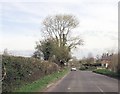
Junction of B4016 with Hagbourne Road
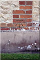
Here the B4016 changes from Bessels Way (Blewbury) to Blewbury Road. The houses are 1 & 2 Sheencroft Cottages. In 1973 the Ordnance Survey levelled a rivet benchmark at 56.91m above Newlyn Datum on a stone on the NE side of the road junction, 7.6m west of a fence junction, 10cm above ground level. I suspect the stone was where the heavy traffic restriction sign is now - no sign of a stone now - it was possibly an old gatepost.
Image: © Roger Templeman
Taken: 19 Mar 2012
0.05 miles
4
Hagbourne Road junction from Bessel's Way
Image: © John Firth
Taken: 4 Apr 2014
0.07 miles
5
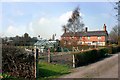
Benchmark on Millbrook Farmhouse
Ordnance Survey cut mark benchmark described on the Bench Mark Database at http://www.bench-marks.org.uk/bm42023
Image: © Roger Templeman
Taken: 19 Mar 2012
0.15 miles
6
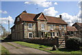
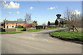
Millbrook Farm House
There is an OS benchmark Image on the side of the house
Image: © Roger Templeman
Taken: 19 Mar 2012
0.15 miles
7
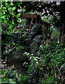
Remains of the Water Wheel
See Image
This is just about visible from the end of the footpath.
Image: © Des Blenkinsopp
Taken: 22 Sep 2010
0.18 miles
9
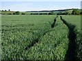
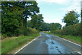
Farmland, Blewbury
Looking south over wheat from the junction of Bessel's Way and Hagbourne Road.
Image: © Andrew Smith
Taken: 6 Jun 2019
0.19 miles
10
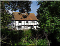
Blewbury Mill
As shown on the map, the footpath comes to a stop on the river bank with no access to Blewbury Mill house.
The Mill Brook is right in the foreground down amongst the leaves.
This is the best view of the house through the trees.
The remains of the water wheel and associated structure are deep in undergrowth to the right of this picture and are in a very derelict condition.
I guess the path was to the mill itself rather than the house, and the right of way still exists although the mill building is no more.
Image: © Des Blenkinsopp
Taken: 22 Sep 2010
0.22 miles