IMAGES TAKEN NEAR TO
Aston Tirrold, DIDCOT, OX11 9DP
Introduction
This page details the photographs taken nearby to OX11 9DP by members of the Geograph project.
The Geograph project started in 2005 with the aim of publishing, organising and preserving representative images for every square kilometre of Great Britain, Ireland and the Isle of Man.

There are currently over 7.5m images from over14,400 individuals and you can help contribute to the project by visiting https://www.geograph.org.uk
Image Map (Loading...)


Getting Data...Please wait
Leaflet Map data © OpenStreetMap
Images are licensed for reuse under creativecommons.org/licenses/by-sa/2.0
Notes
- Clicking on the map will re-center to the selected point.
- The higher the marker number, the further away the image location is from the centre of the postcode.
Image Listing (5 Images Found)
Images are licensed for reuse under creativecommons.org/licenses/by-sa/2.0
Image
Details
Distance
1
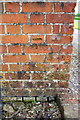
Benchmark on Carrimers Farm barn
Ordnance Survey cut mark benchmark described on the Bench Mark Database at http://www.bench-marks.org.uk/bm58066
Image: © Roger Templeman
Taken: 3 Jun 2014
0.02 miles
2
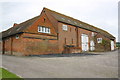
Large barn at Carrimers Farm
There is an OS benchmark Image on the near corner of the jutting part of the building on the face towards the camera
Image: © Roger Templeman
Taken: 3 Jun 2014
0.02 miles
4
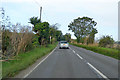
A417 towards Wantage
Heading into rain.
Image: © Robin Webster
Taken: 22 Aug 2020
0.20 miles
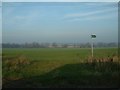
5
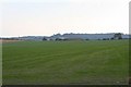
Carrimers Farm across the field
View across the farmland towards Carrimers Farm
Image: © Bill Nicholls
Taken: 28 Sep 2008
0.21 miles