IMAGES TAKEN NEAR TO
Cavendish Park, DIDCOT, OX11 8EF
Introduction
This page details the photographs taken nearby to Cavendish Park, OX11 8EF by members of the Geograph project.
The Geograph project started in 2005 with the aim of publishing, organising and preserving representative images for every square kilometre of Great Britain, Ireland and the Isle of Man.

There are currently over 7.5m images from over14,400 individuals and you can help contribute to the project by visiting https://www.geograph.org.uk
Image Map (Loading...)


Getting Data...Please wait
Leaflet Map data © OpenStreetMap
Images are licensed for reuse under creativecommons.org/licenses/by-sa/2.0
Notes
- Clicking on the map will re-center to the selected point.
- The higher the marker number, the further away the image location is from the centre of the postcode.
Image Listing (84 Images Found)
Images are licensed for reuse under creativecommons.org/licenses/by-sa/2.0
Image
Details
Distance
1
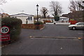
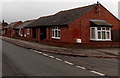
10mph speed limit in Cavendish Park, Didcot
The speed limit sign is alongside the ramp across the access road from Hagbourne Road to
Cavendish Park, a semi-retirement community of park homes http://www.geograph.org.uk/photo/4268057 for people aged at least 50.
Image: © Jaggery
Taken: 4 Dec 2014
0.01 miles
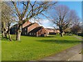
2
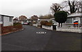
Entrance to Cavendish Park, Didcot
From Hagbourne Road opposite Kynaston Road. Cavendish Park is a semi-retirement community of park homes for people aged at least 50. A park home is a detached bungalow-style house, usually in a private estate, as here, located on plots known as pitches. Legally, they are mobile homes and are covered by their own legislation.
Image: © Jaggery
Taken: 4 Dec 2014
0.01 miles
3
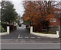
Hagbourne Road houses north of Kynaston Road, Didcot
Houses on the east side of Hagbourne Road, viewed from the corner of Kynaston Road.
Image: © Jaggery
Taken: 4 Dec 2014
0.03 miles
4
Western Avenue, Cavendish Park, Didcot
On the east side of Hagbourne Road, Cavendish Park is a semi-retirement community of park homes for people aged at least 50. A park home is a detached bungalow-style house, usually in a private estate, as here, located on plots known as pitches. Legally, they are mobile homes and are covered by their own legislation.
Image: © Jaggery
Taken: 4 Dec 2014
0.03 miles
5
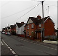
Hagbourne Road bungalows in Didcot
South of the Wessex Road junction.
Image: © Jaggery
Taken: 4 Dec 2014
0.04 miles
6
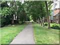
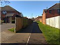
Path heading along by Jubilee Way
Path of old Didcot Newbury railway line heading along by Jubilee Way
Image: © Shaun Ferguson
Taken: 14 Sep 2017
0.04 miles
8
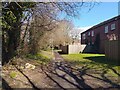
National Cycle Route 544
Flats on Nuffield Close to the right.
Image: © Oscar Taylor
Taken: 3 Mar 2024
0.05 miles
9
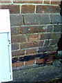
Benchmark on #27H Hagbourne Road
Ordnance Survey cut mark benchmark described on the Bench Mark Database at http://www.bench-marks.org.uk/bm22881
Image: © Roger Templeman
Taken: 7 Dec 2010
0.05 miles
10
National Cycle Route 544
Passing Dirac Place on the left.
Image: © Oscar Taylor
Taken: 3 Mar 2024
0.06 miles