IMAGES TAKEN NEAR TO
Wessex Road, DIDCOT, OX11 8BX
Introduction
This page details the photographs taken nearby to Wessex Road, OX11 8BX by members of the Geograph project.
The Geograph project started in 2005 with the aim of publishing, organising and preserving representative images for every square kilometre of Great Britain, Ireland and the Isle of Man.

There are currently over 7.5m images from over14,400 individuals and you can help contribute to the project by visiting https://www.geograph.org.uk
Image Map (Loading...)


Getting Data...Please wait
Leaflet Map data © OpenStreetMap
Images are licensed for reuse under creativecommons.org/licenses/by-sa/2.0
Notes
- Clicking on the map will re-center to the selected point.
- The higher the marker number, the further away the image location is from the centre of the postcode.
Image Listing (187 Images Found)
Images are licensed for reuse under creativecommons.org/licenses/by-sa/2.0
Image
Details
Distance
1
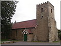
Northbourne Community Centre
Northbourne Community Centre, formerly St Peter's church Northbourne, built 1891.
Image: © Dennis Jackson
Taken: 8 Oct 2005
0.03 miles
2
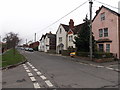
West along Wessex Road, Didcot
From the High Street crossroads.
Image: © Jaggery
Taken: 4 Dec 2014
0.04 miles
3
Pease Place, Didcot
From High Street near the corner of Wessex Road. The white-on-red notice on the fence shows
PRIVATE PARKING - RESIDENTS ONLY.
Image: © Jaggery
Taken: 4 Dec 2014
0.05 miles
4
Bourne Street, Didcot
Bourne Street is a 120 metre long dead-end street on the west side of High Street. Three BOURNE STREET name signs are in view - one below the No Through Road sign on the left, a faded one above the door on the corner, and one at little more than ankle height between the two doors near the cars.
Image: © Jaggery
Taken: 4 Dec 2014
0.05 miles
5
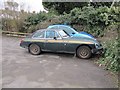
MG in the carpark
An limited edition MGB GT in the car park of Northbourne community centre. Wonder how far it has travelled since it was built in Abingdon.
Image: © Bill Nicholls
Taken: 13 Feb 2010
0.06 miles
6
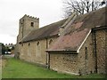
South side of the church
The south side of Northbourne community centre Didcot.
Image: © Bill Nicholls
Taken: 13 Feb 2010
0.07 miles
7
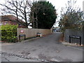
Police station at the end
Didcot police station at the end of Church street.
Image: © Bill Nicholls
Taken: 13 Feb 2010
0.07 miles
8
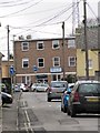
High Street, Didcot
High Street, Didcot, which will join with Wessex Road and Kynaston Road.
Image: © Bill Nicholls
Taken: 13 Feb 2010
0.08 miles
9
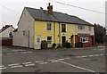
Yellow house on a corner of High Street, Didcot
On the NE corner of High Street and Wessex Road.
Image: © Jaggery
Taken: 4 Dec 2014
0.08 miles
10
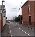
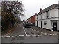
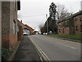
Humps ahead to the left and right, Didcot
High Street approaches Wessex Road where there are speed humps across the road.
Image: © Jaggery
Taken: 4 Dec 2014
0.08 miles