IMAGES TAKEN NEAR TO
Lydalls Road, DIDCOT, OX11 7HX
Introduction
This page details the photographs taken nearby to Lydalls Road, OX11 7HX by members of the Geograph project.
The Geograph project started in 2005 with the aim of publishing, organising and preserving representative images for every square kilometre of Great Britain, Ireland and the Isle of Man.

There are currently over 7.5m images from over14,400 individuals and you can help contribute to the project by visiting https://www.geograph.org.uk
Image Map (Loading...)


Getting Data...Please wait
Leaflet Map data © OpenStreetMap
Images are licensed for reuse under creativecommons.org/licenses/by-sa/2.0
Notes
- Clicking on the map will re-center to the selected point.
- The higher the marker number, the further away the image location is from the centre of the postcode.
Image Listing (414 Images Found)
Images are licensed for reuse under creativecommons.org/licenses/by-sa/2.0
Image
Details
Distance
1
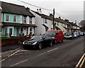
Lydalls Road cars and houses, Didcot
Looking west from the Station Road end. On-street parking on the south side.
Double yellow lines make parking illegal on the north side.
Image: © Jaggery
Taken: 4 Dec 2014
0.01 miles
3
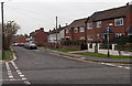
East along Lydalls Road, Didcot
Viewed from the Haydon Road junction. A one-way traffic system, away from the camera, is in force.
Image: © Jaggery
Taken: 4 Dec 2014
0.03 miles
4
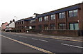
Royal Scot House, Didcot
Royal Scot House at 99 Station Road is the office of Soha (South Oxfordshire Housing Association),
a social landlord managing about 6,000 properties in the county.
Image: © Jaggery
Taken: 4 Dec 2014
0.04 miles
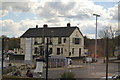
5
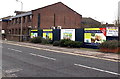
Station Road demolition site, Didcot
At first glance, I thought the poster on the right was showing what is to be built here,
but it refers to a development in Goring-on-Thames. Viewed in December 2014.
Image: © Jaggery
Taken: 4 Dec 2014
0.04 miles
6
Derelict Station Road buildings in Didcot
Viewed in early December 2014. A Google Earth Street View taken in May 2011 shows a Cheque Changers shop in the single-storey premises behind the car. There was an Office to Let notice on a window of the two-storey building on the left. Royal Scot House http://www.geograph.org.uk/photo/4270987 is at the right edge of the view.
Image: © Jaggery
Taken: 4 Dec 2014
0.04 miles
7
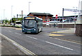
X32 bus for Chilton in Didcot
Thames Travel bus 442 enters Station Road from a bus stop outside Didcot Parkway railway station on Sunday September 3rd 2017. This is the 12:25 pm departure on route X32 to Main Street, Chilton. Scheduled journey time is 22 minutes.
Image: © Jaggery
Taken: 3 Sep 2017
0.05 miles
8
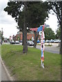
Sustrans cycle route marker in Station Road Didcot
Image: © Rod Allday
Taken: 21 Aug 2008
0.05 miles
9
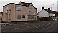
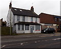
Former Didcot Labour Club
The Station Road building on the corner of Lydalls Road is boarded up in early December 2014.
Image: © Jaggery
Taken: 4 Dec 2014
0.05 miles
10
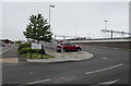
Entrance to Didcot Parkway East Car Park
Didcot Parkway long stay railway station car park entrance from/exit into Station Road.
Image: © Jaggery
Taken: 3 Sep 2017
0.06 miles