1
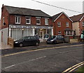
Lydalls Road cars and houses, Didcot
Looking west from the Station Road end. On-street parking on the south side.
Double yellow lines make parking illegal on the north side.
Image: © Jaggery
Taken: 4 Dec 2014
0.03 miles
2
East along Lydalls Road, Didcot
Viewed from the Haydon Road junction. A one-way traffic system, away from the camera, is in force.
Image: © Jaggery
Taken: 4 Dec 2014
0.03 miles
3
West along Edinburgh Drive, Didcot
Viewed from near this http://www.geograph.org.uk/photo/4271184 small roundabout.
Image: © Jaggery
Taken: 4 Dec 2014
0.04 miles
4
The Prince of Wales
Image: © N Chadwick
Taken: 17 Apr 2016
0.05 miles
5
Derelict Station Road buildings in Didcot
Viewed in early December 2014. A Google Earth Street View taken in May 2011 shows a Cheque Changers shop in the single-storey premises behind the car. There was an Office to Let notice on a window of the two-storey building on the left. Royal Scot House http://www.geograph.org.uk/photo/4270987 is at the right edge of the view.
Image: © Jaggery
Taken: 4 Dec 2014
0.06 miles
6
Royal Scot House, Didcot
Royal Scot House at 99 Station Road is the office of Soha (South Oxfordshire Housing Association),
a social landlord managing about 6,000 properties in the county.
Image: © Jaggery
Taken: 4 Dec 2014
0.06 miles
7
Station Road demolition site, Didcot
At first glance, I thought the poster on the right was showing what is to be built here,
but it refers to a development in Goring-on-Thames. Viewed in December 2014.
Image: © Jaggery
Taken: 4 Dec 2014
0.06 miles
8
South and Vale Carers Centre, Didcot
Located at 5 Lydalls Road, near the Station Road junction. The South and Vale Carers Centre provides advice, information and support to unpaid carers in South Oxfordshire and the Vale of White Horse. Their services include expert help to claim disability and other benefits.
Image: © Jaggery
Taken: 4 Dec 2014
0.06 miles
9
Former Didcot Labour Club
The Station Road building on the corner of Lydalls Road is boarded up in early December 2014.
Image: © Jaggery
Taken: 4 Dec 2014
0.07 miles
10
Corner of Station Road and Lydalls Road, Didcot
Lydalls Road is on the left side of the derelict former Didcot Labour Club. http://www.geograph.org.uk/photo/4271378
Image: © Jaggery
Taken: 4 Dec 2014
0.07 miles


