IMAGES TAKEN NEAR TO
Oxford Crescent, DIDCOT, OX11 7AL
Introduction
This page details the photographs taken nearby to Oxford Crescent, OX11 7AL by members of the Geograph project.
The Geograph project started in 2005 with the aim of publishing, organising and preserving representative images for every square kilometre of Great Britain, Ireland and the Isle of Man.

There are currently over 7.5m images from over14,400 individuals and you can help contribute to the project by visiting https://www.geograph.org.uk
Image Map (Loading...)


Getting Data...Please wait
Leaflet Map data © OpenStreetMap
Images are licensed for reuse under creativecommons.org/licenses/by-sa/2.0
Notes
- Clicking on the map will re-center to the selected point.
- The higher the marker number, the further away the image location is from the centre of the postcode.
Image Listing (19 Images Found)
Images are licensed for reuse under creativecommons.org/licenses/by-sa/2.0
Image
Details
Distance
2
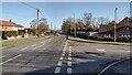
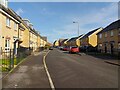
Wantage Road
Wantage Road passing Barleyfields
Image: © Shaun Ferguson
Taken: 2 Dec 2021
0.08 miles
3
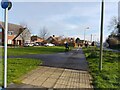
Shared pavement beside Wantage Road, Didcot
Image: © Oscar Taylor
Taken: 3 Mar 2024
0.18 miles
4
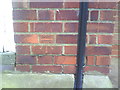
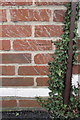
Benchmark on #139 Brasenose Road (Churchill Road face)
Ordnance Survey cut mark benchmark described on the Bench Mark Database at http://www.bench-marks.org.uk/bm21995
Image: © Roger Templeman
Taken: 11 Nov 2010
0.19 miles
5
Blackthorn Road, Didcot
One of the many roads of Great Western Park, a large modern housing development to the west of Didcot.
Image: © Oscar Taylor
Taken: 3 Mar 2024
0.19 miles
6
61-75 Cherry Tree Road, Didcot
One of the many roads of Great Western Park, a large modern housing development to the west of Didcot.
Image: © Oscar Taylor
Taken: 3 Mar 2024
0.20 miles
8
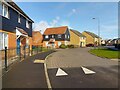
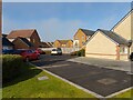
Cherry Tree Road / Blackthorn Road, Didcot
Looking from Cherry Tree Road to Blackthorn Road. The road heading to the left is Mallard Drive. These are all roads of Great Western Park, a large modern housing development to the west of Didcot.
Image: © Oscar Taylor
Taken: 3 Mar 2024
0.20 miles
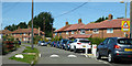
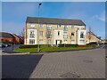
9
61-75 Cherry Tree Road car park
In Great Western Park, a large modern housing development to the west of Didcot.
Image: © Oscar Taylor
Taken: 3 Mar 2024
0.20 miles
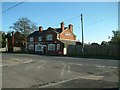
10
Benchmark on The Wheatsheaf pub
Ordnance Survey cut mark benchmark described on the Bench Mark Database at http://www.bench-marks.org.uk/bm21708
Image: © Roger Templeman
Taken: 9 Jan 2012
0.20 miles