IMAGES TAKEN NEAR TO
Miles East, DIDCOT, OX11 6EE
Introduction
This page details the photographs taken nearby to Miles East, OX11 6EE by members of the Geograph project.
The Geograph project started in 2005 with the aim of publishing, organising and preserving representative images for every square kilometre of Great Britain, Ireland and the Isle of Man.

There are currently over 7.5m images from over14,400 individuals and you can help contribute to the project by visiting https://www.geograph.org.uk
Image Map
Images are licensed for reuse under creativecommons.org/licenses/by-sa/2.0
Notes
- Clicking on the map will re-center to the selected point.
- The higher the marker number, the further away the image location is from the centre of the postcode.
Image Listing (23 Images Found)
Images are licensed for reuse under creativecommons.org/licenses/by-sa/2.0
Image
Details
Distance
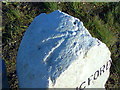
1

Seven Miles
Recently refurbished milestone.
Wallingford 7 Wantage 7
Image: © Ian Poffley
Taken: 20 Jun 2007
0.04 miles
2
Benchmark on milestone beside Harwell Road (B4493)
Ordnance Survey rivet benchmark described on the Bench Mark Database at http://www.bench-marks.org.uk/bm22711
Image: © Roger Templeman
Taken: 29 Dec 2007
0.06 miles
3
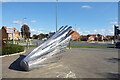
Silver Sculpture
On a prominent site by a crossroads in front of a college.
Image: © Des Blenkinsopp
Taken: 7 Oct 2020
0.07 miles
4

Old Milestone, Didcot Road, Harwell
Carved stone post by the B4493, in parish of Harwell (Vale of White Horse District), Didcot Road; near Alma Barn, on open grass verge by ditch, just East of 30 sign, on North side of road. Vale triangular, erected by the Wallingford, Wantage & Faringdon Turnpike Trust in the 19th century.
Inscription reads:-
: WALLINGFORD / 7 : : WANTAGE / 7 :
Grade II listed. List Entry Number: 1199798
https://historicengland.org.uk/listing/the-list/list-entry/1199798
Milestone Society National ID: BE_WAWL07.
Image: © Milestone Society
Taken: 8 Dec 2016
0.07 miles
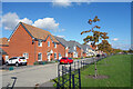
5
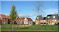
Park and Houses, Diamond Drive
Part of the big recent expansion of Didcot on the west side of the town.
Image: © Des Blenkinsopp
Taken: 7 Oct 2020
0.08 miles
6
Greenwood Way, Didcot
Part of the big recent expansion of Didcot on the west side of the town.
Image: © Des Blenkinsopp
Taken: 7 Oct 2020
0.11 miles
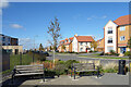
7

Larkmead Vets and The Cutting Bar
Business premises off Greenwood Way.
Image: © Des Blenkinsopp
Taken: 7 Oct 2020
0.12 miles
8
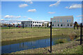
Small Pond near the College
In my 2004 picture at this location Image I predicted that the arable landscape shown would soon be built over.
Partly but not totally correct. Some of the area is still fields, but for college sports rather than farming.
Image: © Des Blenkinsopp
Taken: 7 Oct 2020
0.14 miles
9
Holly Lane, Ddcot
New housing set back from the main road, with a lawn in front.
Image: © Des Blenkinsopp
Taken: 7 Oct 2020
0.15 miles
10

Mistletoe Mews, Didcot
Part of the large Great Western Park housing development; one of many roads taking their name from plants
Image: © David Smith
Taken: 9 Jun 2018
0.16 miles