IMAGES TAKEN NEAR TO
Didcot Road, DIDCOT, OX11 6DW
Introduction
This page details the photographs taken nearby to Didcot Road, OX11 6DW by members of the Geograph project.
The Geograph project started in 2005 with the aim of publishing, organising and preserving representative images for every square kilometre of Great Britain, Ireland and the Isle of Man.

There are currently over 7.5m images from over14,400 individuals and you can help contribute to the project by visiting https://www.geograph.org.uk
Image Map
Images are licensed for reuse under creativecommons.org/licenses/by-sa/2.0
Notes
- Clicking on the map will re-center to the selected point.
- The higher the marker number, the further away the image location is from the centre of the postcode.
Image Listing (28 Images Found)
Images are licensed for reuse under creativecommons.org/licenses/by-sa/2.0
Image
Details
Distance
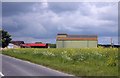
2
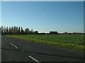
Didcot Road
Didcot Road passing Zulu Farm with opposite another housing development coming soon
Image: © Shaun Ferguson
Taken: 2 Dec 2021
0.05 miles
3
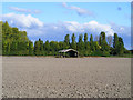
Farmland and barn, Harwell
Looking across to Alma Barn from the bridleway beside the A34.
Image: © Andrew Smith
Taken: 17 Oct 2010
0.06 miles
4
Zulu Farm, Didcot Road
There is an OS benchmark Image on the building in the centre of the photograph. The road on the left is the B4493.
Image: © Roger Templeman
Taken: 10 Feb 2012
0.07 miles
5
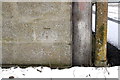
Benchmark on building at Zulu Farm
Ordnance Survey cut mark benchmark described on the Bench Mark Database at http://www.bench-marks.org.uk/bm22709
Image: © Roger Templeman
Taken: 10 Feb 2012
0.07 miles
6
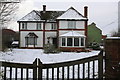
Zulu Farmhouse, Didcot Road
There is an OS benchmark Image on the chimney breast on the right hand side of the house.
Image: © Roger Templeman
Taken: 10 Feb 2012
0.07 miles
7
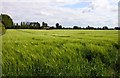
Alma Barn in a wheat field near Harwell
Image: © Steve Daniels
Taken: 21 May 2009
0.08 miles
8
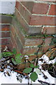
Benchmark on chimney breast of Zulu Farmhouse
Ordnance Survey cut mark benchmark described on the Bench Mark Database at http://www.bench-marks.org.uk/bm24362
Image: © Roger Templeman
Taken: 10 Feb 2012
0.08 miles
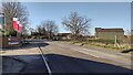
10
Turning off B4493 to a pair of houses
The turning leads to a pair of houses on the north side of Didcot Road. Through the trees cooling towers of Didcot Power Station
Image: © Roger Templeman
Taken: 10 Feb 2012
0.12 miles