
IMAGES TAKEN NEAR TO
Sandpiper Walk, DIDCOT, OX11 6BB
Introduction
This page details the photographs taken nearby to Sandpiper Walk, OX11 6BB by members of the Geograph project.
The Geograph project started in 2005 with the aim of publishing, organising and preserving representative images for every square kilometre of Great Britain, Ireland and the Isle of Man.

There are currently over 7.5m images from over14,400 individuals and you can help contribute to the project by visiting https://www.geograph.org.uk
Image Map
Images are licensed for reuse under creativecommons.org/licenses/by-sa/2.0
Notes
- Clicking on the map will re-center to the selected point.
- The higher the marker number, the further away the image location is from the centre of the postcode.
Image Listing (44 Images Found)
Images are licensed for reuse under creativecommons.org/licenses/by-sa/2.0
Image
Details
Distance
1
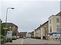
Sir Frank Williams Avenue, Didcot and Best One shop
A modern corner shop to serve part of the large housing estate in Great Western Park
Image: © David Smith
Taken: 9 Jun 2018
0.04 miles
2
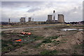
Didcot Field, now a construction site
A view of cooling towers at Didcot Power Stations that may soon be lost either by the building of new houses here or the felling of the towers as the coal-fueled power station reaches the end of its life.
Image: © Roger Templeman
Taken: 9 Jan 2012
0.05 miles
3
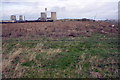
Footpath across Didcot Field
The Didcot Power Stations are visible on the horizon.
Image: © Roger Templeman
Taken: 9 Jan 2012
0.06 miles
4
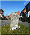
War Memorial, Lisa Head Avenue
A close view of the memorial shown in Image Neighbouring streets are named after local military workers who died in wars in Iraq and Afghanistan. There is a MoD depot in Didcot.
Image: © Des Blenkinsopp
Taken: 26 Feb 2021
0.07 miles
5
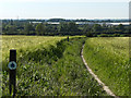
Barley fields at Didcot
The northern of the two footpaths that encroach into the gridsquare. The shiny buildings are the Milton Park Estate.
Image: © Andrew Smith
Taken: 3 Jun 2006
0.07 miles
6
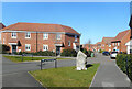
Lisa Head Avenue, Didcot
"In honour of Captain Lisa Head" is part of the street name sign. Neighbouring streets on a new development carry the names of other members of the military services who worked for the MoD in Didcot and who were killed in the Iraq and Afghanistan wars.
Image: © Des Blenkinsopp
Taken: 26 Feb 2021
0.08 miles
8

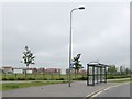
And they are gone
The landmark towers at Didcot Power station have gone from view, the other three still have to go, along with the generator house and stack
Image
Image: © Bill Nicholls
Taken: 27 Jul 2014
0.09 miles
9
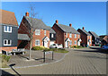
Maple Road, Didcot
Many of the nearby streets in this recently built neighbourhood are named after trees or flowers or birds.
Image: © Des Blenkinsopp
Taken: 26 Feb 2021
0.09 miles
10

The end
The first of the cooling towers of Didcot Power Station starts to come down as part of the demolition.
Image
Image: © Bill Nicholls
Taken: 27 Jul 2014
0.10 miles