IMAGES TAKEN NEAR TO
Becquerel Avenue, DIDCOT, OX11 0TA
Introduction
This page details the photographs taken nearby to Becquerel Avenue, OX11 0TA by members of the Geograph project.
The Geograph project started in 2005 with the aim of publishing, organising and preserving representative images for every square kilometre of Great Britain, Ireland and the Isle of Man.

There are currently over 7.5m images from over14,400 individuals and you can help contribute to the project by visiting https://www.geograph.org.uk
Image Map
Images are licensed for reuse under creativecommons.org/licenses/by-sa/2.0
Notes
- Clicking on the map will re-center to the selected point.
- The higher the marker number, the further away the image location is from the centre of the postcode.
Image Listing (23 Images Found)
Images are licensed for reuse under creativecommons.org/licenses/by-sa/2.0
Image
Details
Distance
1

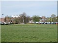
Hangar in the distance
View from the mound on the Rutherford site looking towards the old ARF 'C'type hangar which is the only one remaining.
Image: © Bill Nicholls
Taken: 30 Jun 2011
0.09 miles
2
Side of a Hangar
View of the side of the remaining C Hangar at Harwell which has been changed with additions during its time with the UKAEA.
Image: © Bill Nicholls
Taken: 6 Apr 2011
0.12 miles
3
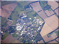
Harwell Science and Innovation Campus
Multiple research facilities and organisations are based on this large site near Didcot.
Image: © M J Richardson
Taken: 26 Sep 2015
0.14 miles
4

The Last Hangar
This is the last C Type Hangar on the Harwell site; the other two were demolished a few years ago, though you can make it out in this photo. Image
Image: © Bill Nicholls
Taken: 6 Apr 2011
0.14 miles
6

Building on the doors
On this end of the S Type Hangar there would have been some huge sliding doors to allow aircraft in; these have been removed and a building was built in place while it belonged to UKAEA. The place looks as if it is in the process of being decommissioned now.
Image: © Bill Nicholls
Taken: 6 Apr 2011
0.17 miles
7
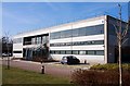
The International Space Innovation Centre on Fermi Avenue
Since its launch in May 2011, the not-for-profit organisation – which is a partnership between industry, academia and government – has raised awareness of ways other market sectors can use space-derived data and technologies to develop new products and services to enhance their business, connecting the appropriate expertise to help identify solutions, including the right partners and funding routes.
Image: © Steve Daniels
Taken: 18 Feb 2013
0.20 miles
8
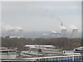
Steaming away
Sure sign it is winter as Didcot Power Station can be seen steaming away in the distance from the Mound at Rutherford Laboratory.
Image: © Bill Nicholls
Taken: 28 Nov 2011
0.22 miles
9
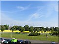
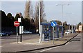
Fence on Firmi Avenue
Since the last photo I submitted a fence has gone up Image and I might add that since then the trees have all been cut down.
Image: © Bill Nicholls
Taken: 19 May 2014
0.22 miles
10

Frome Road
View along the main road into the Harwell Campus, this was the second runway back in the second world war now it is just a memory. Diamond Light Source can be seen on the right.
Image: © Bill Nicholls
Taken: 3 Oct 2011
0.22 miles