IMAGES TAKEN NEAR TO
Ferry Way, WALLINGFORD, OX10 9JX
Introduction
This page details the photographs taken nearby to Ferry Way, OX10 9JX by members of the Geograph project.
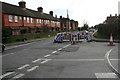
The Geograph project started in 2005 with the aim of publishing, organising and preserving representative images for every square kilometre of Great Britain, Ireland and the Isle of Man.

There are currently over 7.5m images from over14,400 individuals and you can help contribute to the project by visiting https://www.geograph.org.uk
Image Map (Loading...)


Getting Data...Please wait
Leaflet Map data © OpenStreetMap
Images are licensed for reuse under creativecommons.org/licenses/by-sa/2.0
Notes
- Clicking on the map will re-center to the selected point.
- The higher the marker number, the further away the image location is from the centre of the postcode.
Image Listing (350 Images Found)
Images are licensed for reuse under creativecommons.org/licenses/by-sa/2.0
Image
Details
Distance
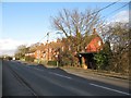
1
Ferry Lane
Ferry Lane leading down to the river Thames, the housing on the right used to be housing for Fairmile Hospital nurses. You can just see the new houses which mark Ferry Way just off the lane.
Image: © Bill Nicholls
Taken: 17 Feb 2008
0.01 miles
2
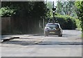
Back of Google
I have been wanting to get a photo of the Google car for ages now and I nearly missed it only spotting it driving past as I was walking back to my car on the Fairmile site, I had to run and got the back as it drove away. Wonder if I was photographed.
Image: © Bill Nicholls
Taken: 20 May 2011
0.02 miles
3
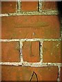
Benchmark under a shrub
This is the benchmark on 9 Reading Road in Cholsey which is under a shrub by the corner of the house. A friend of mine was living there at the time and let me get a photo.
Image: © Bill Nicholls
Taken: 8 Aug 2010
0.03 miles
4
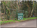
New signage
New signage on Ferry Lane Cholsey advertising the new housing being built.
Image: © Bill Nicholls
Taken: 20 Feb 2011
0.03 miles
5

Nos 1-9 (odds) Reading Road at Ferry Lane junction
There is an OS benchmark Image on the front of the nearest house on its left hand corner
Image: © Roger Templeman
Taken: 10 Jun 2014
0.03 miles
6
Gas works on the corner
British Gas doing some work on Hospital corner Cholsey.
Image: © Bill Nicholls
Taken: 20 Feb 2009
0.03 miles
7
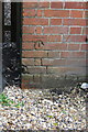
Benchmark on #9 Reading Road
Ordnance Survey cut mark benchmark described on the Bench Mark Database at http://www.bench-marks.org.uk/bm26980
Image: © Roger Templeman
Taken: 10 Jun 2014
0.03 miles
8
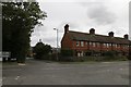
Ferry Way
The housing used to be part of the old Fair Mile hospital accommodation, Ferry Lane takes you to the River Thames and was called Papist Way many years ago
Image: © Bill Nicholls
Taken: 2 Oct 2017
0.03 miles
9
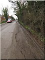
Signs of strain
The Ferry Lane road bed showing signs of strain under the constant use of construction traffic.
Image: © Bill Nicholls
Taken: 20 Feb 2011
0.03 miles
10
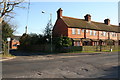
Housing on the Reading road
This row of houses are ex Fairmile Hospital houses that used to be given to nursing staff.
Image: © Bill Nicholls
Taken: 20 Feb 2010
0.03 miles