IMAGES TAKEN NEAR TO
Thames View, WALLINGFORD, OX10 9FR
Introduction
This page details the photographs taken nearby to Thames View, OX10 9FR by members of the Geograph project.
The Geograph project started in 2005 with the aim of publishing, organising and preserving representative images for every square kilometre of Great Britain, Ireland and the Isle of Man.

There are currently over 7.5m images from over14,400 individuals and you can help contribute to the project by visiting https://www.geograph.org.uk
Image Map
Images are licensed for reuse under creativecommons.org/licenses/by-sa/2.0
Notes
- Clicking on the map will re-center to the selected point.
- The higher the marker number, the further away the image location is from the centre of the postcode.
Image Listing (351 Images Found)
Images are licensed for reuse under creativecommons.org/licenses/by-sa/2.0
Image
Details
Distance
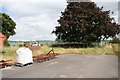
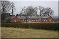
1
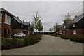
Housing on Thames View
Part of the Cholsey Meadows site
Image: © Bill Nicholls
Taken: 2 Oct 2017
0.02 miles
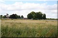
2
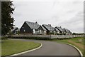
Thames View
The only part of the Cholsey Meadows site not named after Fair Mile
Image: © Bill Nicholls
Taken: 2 Oct 2017
0.02 miles
3
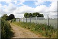
Secure unit
The fence from the secure unit which was here.
Image: © Bill Nicholls
Taken: 29 Jun 2008
0.03 miles
4
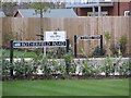
Two Signs
Rotherfield Road named after the ward that was nearby and Thames View which I might add you cannot see from the houses in the road at the Fairmile development Cholsey
Image: © Bill Nicholls
Taken: 4 Dec 2015
0.03 miles
5
Tree by the fence
A Tree stands by the corner of the fenced off secure unit.
Image: © Bill Nicholls
Taken: 29 Jun 2008
0.03 miles
6
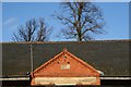
Roof of the Rotherfield
I took this to show the date stone set in the apex of the entrance; it's dated 1894. Shame as I think this building is one of those destined to be demolished when the building starts.
Image: © Bill Nicholls
Taken: 18 Jan 2009
0.04 miles
7
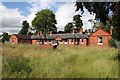
Rotherfield Ward
This is a Victorian bungalow built as part of the old Hospital. In latter years it was made into a secure ward.
Image: © Bill Nicholls
Taken: 29 Jun 2008
0.04 miles
8
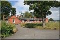
Road to the ward
Road leading to the Rotherfield Ward. The entrance area is more recent that the rest of the building.
Image: © Bill Nicholls
Taken: 29 Jun 2008
0.04 miles
9
Rotherfield Ward
Disused Rotherfield Ward hospital wing at Fairmile.
Image: © Bill Nicholls
Taken: 19 Jan 2008
0.04 miles
10
Secure unit in the distance
Could not say what this area was used for but in the distance you can see the fence from the secure unit of the hospital.
Image: © Bill Nicholls
Taken: 29 Jun 2008
0.04 miles