IMAGES TAKEN NEAR TO
Orchard Haven, WALLINGFORD, OX10 7JN
Introduction
This page details the photographs taken nearby to Orchard Haven, OX10 7JN by members of the Geograph project.
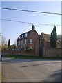
The Geograph project started in 2005 with the aim of publishing, organising and preserving representative images for every square kilometre of Great Britain, Ireland and the Isle of Man.

There are currently over 7.5m images from over14,400 individuals and you can help contribute to the project by visiting https://www.geograph.org.uk
Image Map
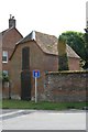
Images are licensed for reuse under creativecommons.org/licenses/by-sa/2.0
Notes
- Clicking on the map will re-center to the selected point.
- The higher the marker number, the further away the image location is from the centre of the postcode.
Image Listing (389 Images Found)
Images are licensed for reuse under creativecommons.org/licenses/by-sa/2.0
Image
Details
Distance
1
Storehouse on the corner
Could not say what this building is used for other than some kind of store, it's along Bridge end Dorchester.
Image: © Bill Nicholls
Taken: 10 May 2009
0.03 miles
2
Dorchester on Thames: Bridge End (2)
View away from the town centre, and towards the flood-plain of the little River Thame.
Image: © Stefan Czapski
Taken: 11 Apr 2019
0.03 miles
3
End of Bridge end
Bridge end goes on a fit further here I turned right for the Dyke hills near Dorchester.
Image: © Bill Nicholls
Taken: 10 May 2009
0.03 miles
4
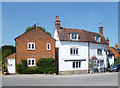
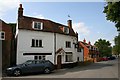
The Old Chequers, Bridge End
Still with a smart sign outside, but it hasn't been a pub for years.
Image: © Des Blenkinsopp
Taken: 7 May 2020
0.04 miles
5
Another lost pub
Another pub lost to us just along Bridge end Dorchester.
Image: © Bill Nicholls
Taken: 10 May 2009
0.05 miles
6
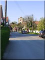
Dorchester on Thames: Bridge End (1)
View towards the town centre.
The little red-brtick building in the distance must once have been a toll-house, at the approach to Dorchester Bridge. Beyond the toll-house is the tower of the abbey church.
Image: © Stefan Czapski
Taken: 11 Apr 2019
0.05 miles
7
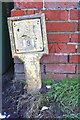
Benchmark on Wittenham Lane outbuilding
The Ordnance Survey cut mark benchmark to the right of a hydrant marker is described on the Bench Mark Database at http://www.bench-marks.org.uk/bm50909
Image: © Roger Templeman
Taken: 4 Feb 2015
0.05 miles
8
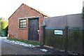
Outbuilding at south end of Wittenham Lane
There is an OS benchmark Image to the right of the hydrant marker at the far front corner of the building
Image: © Roger Templeman
Taken: 4 Feb 2015
0.05 miles
9
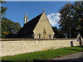
Church of St Birinus, Dorchester on Thames
Image: © Gareth James
Taken: 27 Sep 2015
0.06 miles
10
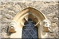
Headstops on the end two
Second set of headstops that are on the windows of St Birinus church Dorchester by the statue.
Image: © Bill Nicholls
Taken: 10 May 2009
0.06 miles