IMAGES TAKEN NEAR TO
Thame Road, WALLINGFORD, OX10 7DH
Introduction
This page details the photographs taken nearby to Thame Road, OX10 7DH by members of the Geograph project.
The Geograph project started in 2005 with the aim of publishing, organising and preserving representative images for every square kilometre of Great Britain, Ireland and the Isle of Man.

There are currently over 7.5m images from over14,400 individuals and you can help contribute to the project by visiting https://www.geograph.org.uk
Image Map (Loading...)


Getting Data...Please wait
Leaflet Map data © OpenStreetMap
Images are licensed for reuse under creativecommons.org/licenses/by-sa/2.0
Notes
- Clicking on the map will re-center to the selected point.
- The higher the marker number, the further away the image location is from the centre of the postcode.
Image Listing (32 Images Found)
Images are licensed for reuse under creativecommons.org/licenses/by-sa/2.0
Image
Details
Distance
1
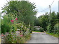
Hammer Lane, Warborough 2
Looking south-east towards the village.
The verges are dotted with self-sown hollyhocks.
Image: © Jonathan Billinger
Taken: 9 Jul 2009
0.05 miles
3
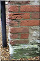
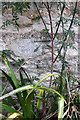
Benchmark on barn conversion at #235 Thame Road
Ordnance Survey cut mark benchmark described on the Bench Mark Database at http://www.bench-marks.org.uk/bm50932
Image: © Roger Templeman
Taken: 27 Nov 2013
0.10 miles
4
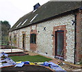
#235 Thame Road and new garden beds
There is an OS benchmark Image on a corner brick at the right hand edge of the image
Image: © Roger Templeman
Taken: 27 Nov 2013
0.10 miles
5
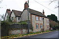
Court Farm house
There is an OS benchmark Image on the near corner of the house (roadface) at its junction with the stone wall
Image: © Roger Templeman
Taken: 27 Nov 2013
0.11 miles
6
Benchmark on Court Farm house
Ordnance Survey cut mark benchmark described on the Bench Mark Database at http://www.bench-marks.org.uk/bm50931
Image: © Roger Templeman
Taken: 27 Nov 2013
0.11 miles
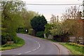
8
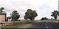
A329 Thame Road
Making its bendy way towards Thame past Upper Farm.
Image: © Robin Webster
Taken: 23 Jun 2019
0.13 miles
10
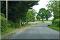
Hammer Lane, Warborough 1
Looking north-west from the end of the metalled part of the lane where it becomes a track.
Image: © Jonathan Billinger
Taken: 9 Jul 2009
0.14 miles