IMAGES TAKEN NEAR TO
St. Helens Avenue, WALLINGFORD, OX10 6RU
Introduction
This page details the photographs taken nearby to St. Helens Avenue, OX10 6RU by members of the Geograph project.
The Geograph project started in 2005 with the aim of publishing, organising and preserving representative images for every square kilometre of Great Britain, Ireland and the Isle of Man.

There are currently over 7.5m images from over14,400 individuals and you can help contribute to the project by visiting https://www.geograph.org.uk
Image Map
Images are licensed for reuse under creativecommons.org/licenses/by-sa/2.0
Notes
- Clicking on the map will re-center to the selected point.
- The higher the marker number, the further away the image location is from the centre of the postcode.
Image Listing (71 Images Found)
Images are licensed for reuse under creativecommons.org/licenses/by-sa/2.0
Image
Details
Distance
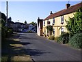
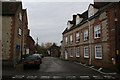
1
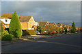
St Helen's Avenue, Benson
The road has houses on one side and fields and allotments on the other. It is very wide for a road of its importance since it was, until the building of the airfield, the main Oxford to Henley road.
Image: © Andrew Smith
Taken: 15 Nov 2008
0.07 miles
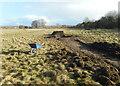
2
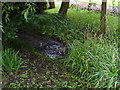
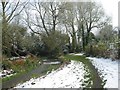
Site off The Moorlands, Benson
Brook at bottom of site, which, according to the Environment Agency, may flood if the site is developed. There is a weir a short distance away downstream!!
Image: © MICHAEL ZAWADZKI
Taken: 23 Jul 2007
0.12 miles
3
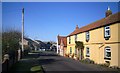
Old London Road, Benson
As the name says, this was the main road through Benson prior to the building of the airfield in WW2. Now it's a residential street with a mix of original and post war housing as seen here.
Image: © Des Blenkinsopp
Taken: 14 Jan 2012
0.15 miles
4
Allotments and Dead Sunflower
There is a public footpath through the middle of these allotments.
Image: © Des Blenkinsopp
Taken: 14 Jan 2012
0.15 miles
5
Old London Road, Benson
The gradual development of the village can be seen in houses of many different eras. It continues to grow today.
Image: © Andrew Smith
Taken: 29 Jun 2018
0.16 miles
6
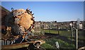
Digging the field up
Work in progress by the look of it.
At a guess the kids are making a bike jump.
Beside a footpath near the allotments.
Image: © Des Blenkinsopp
Taken: 18 Feb 2021
0.16 miles
7
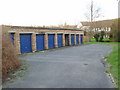
Off The Moorlands, Benson
1960's garages to be demolished and replaced by two Low Carbon houses and new garages.
Image: © MICHAEL ZAWADZKI
Taken: 2 Feb 2007
0.16 miles
8
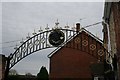
Arch on the gateway
Rather smart looking arch on a gateway along Mill Street Benson, it's a shame the gates were not shut as they were impressive as well
Image: © Bill Nicholls
Taken: 5 Dec 2009
0.17 miles
10
Mill Lane
Mill Lane Benson, not sure where the Mill was though
Image: © Bill Nicholls
Taken: 5 Dec 2009
0.17 miles