IMAGES TAKEN NEAR TO
Forest Row, WALLINGFORD, OX10 6PU
Introduction
This page details the photographs taken nearby to Forest Row, OX10 6PU by members of the Geograph project.
The Geograph project started in 2005 with the aim of publishing, organising and preserving representative images for every square kilometre of Great Britain, Ireland and the Isle of Man.

There are currently over 7.5m images from over14,400 individuals and you can help contribute to the project by visiting https://www.geograph.org.uk
Image Map (Loading...)


Getting Data...Please wait
Leaflet Map data © OpenStreetMap
Images are licensed for reuse under creativecommons.org/licenses/by-sa/2.0
Notes
- Clicking on the map will re-center to the selected point.
- The higher the marker number, the further away the image location is from the centre of the postcode.
Image Listing (13 Images Found)
Images are licensed for reuse under creativecommons.org/licenses/by-sa/2.0
Image
Details
Distance
1
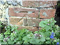
Benchmark on #1 Forest Row
Ordnance Survey cut mark benchmark described on the Bench Mark Database at http://www.bench-marks.org.uk/bm37471
Image: © Roger Templeman
Taken: 4 Apr 2011
0.02 miles
2
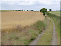
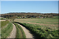
Chiltern landscape near Ipsden
Ripening barley in the field to the left. The track is classified as a byway.
Image: © Alan Murray-Rust
Taken: 9 Jul 2014
0.09 miles
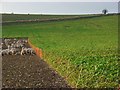
3
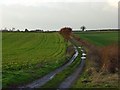
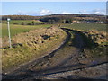
Track in farmland, Crowmarsh
The restricted byway heading west from Forest Row. To the left is a crop of a root vegetable and to the right is cereal.
Image: © Andrew Smith
Taken: 2 Dec 2007
0.09 miles
4
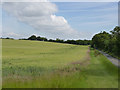
Chiltern landscape near Ipsden
The line of trees on the horizon marks the line of Grim's Ditch, a linear Iron Age earthwork (Scheduled Monument). The mown strip at the edge of the field is a permissive bridleway to allow equestrians and walkers to follow the Chiltern Way, nominally along the road itself. The road follows the line of Iknield Way, also a prehistoric route.
Image: © Alan Murray-Rust
Taken: 9 Jul 2014
0.11 miles
6
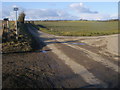
Lane to Crowmarsh Gifford
Lane to Crowmarsh Gifford part of National Cycle Route 5
Image: © Shaun Ferguson
Taken: 10 Feb 2010
0.13 miles
7
Farmland, Crowmarsh
Turnips (or some other root vegetable) for animal feed (see http://www.geograph.org.uk/photo/627304 ), cereal and a colourful tree beside a track (see http://www.geograph.org.uk/photo/627293 ).
Image: © Andrew Smith
Taken: 2 Dec 2007
0.14 miles
8
Farmland, Crowmarsh
Sheep on apparently bare ground but feeding on turnips or something similar. The field will be gradually grazed with the sheep controlled by the temporary fencing.
Image: © Andrew Smith
Taken: 2 Dec 2007
0.14 miles
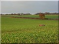
9
Towards Forest Row
Farm track and bridleway on the edge of the Chilterns.
Image: © Des Blenkinsopp
Taken: 29 Mar 2021
0.15 miles
10
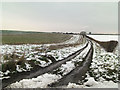
Restricted Byway
Restricted Byway heading to Forest Row
Image: © Shaun Ferguson
Taken: 10 Feb 2010
0.18 miles