IMAGES TAKEN NEAR TO
Cross Close, WALLINGFORD, OX10 6EN
Introduction
This page details the photographs taken nearby to Cross Close, OX10 6EN by members of the Geograph project.
The Geograph project started in 2005 with the aim of publishing, organising and preserving representative images for every square kilometre of Great Britain, Ireland and the Isle of Man.

There are currently over 7.5m images from over14,400 individuals and you can help contribute to the project by visiting https://www.geograph.org.uk
Image Map (Loading...)


Getting Data...Please wait
Leaflet Map data © OpenStreetMap
Images are licensed for reuse under creativecommons.org/licenses/by-sa/2.0
Notes
- Clicking on the map will re-center to the selected point.
- The higher the marker number, the further away the image location is from the centre of the postcode.
Image Listing (11 Images Found)
Images are licensed for reuse under creativecommons.org/licenses/by-sa/2.0
Image
Details
Distance
1

Stile, Ewelme
At the junction of bridleway and footpath on Rabbits Hill. The stile is missing its upper step meaning that it is difficult to use by those without long legs. Stiles can be somewhat hazardous, not just when frosty, but also when damp, muddy or mildewy. The residences of RAF Benson are to the right.
Image: © Andrew Smith
Taken: 7 Dec 2008
0.14 miles
2
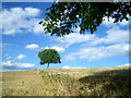
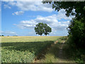
One tree on Rabbits Hill
The footpath follows what must have been a field boundary at one time, now indicated by a slight change in level and a row of nettles.
The line is still marked by a few trees.
Unusually, this one is a Walnut.
Image: © Des Blenkinsopp
Taken: 5 Jul 2010
0.16 miles
3
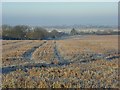
Farmland, Ewelme
A field of stubble with a view over the northern part of RAF Benson.
Image: © Andrew Smith
Taken: 7 Dec 2008
0.16 miles
4
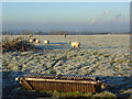
Pasture, Ewelme
On Rabbits Hill with a view of clouds emanating from Didcot Power Station.
Image: © Andrew Smith
Taken: 7 Dec 2008
0.17 miles
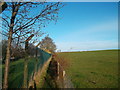
5

Pasture, Ewelme
The line of a footpath on an old field boundary.
Image: © Andrew Smith
Taken: 7 Dec 2008
0.18 miles
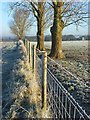
6
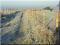
Bridleway, Ewelme
Between pastoral fields on Rabbits Hill.
Image: © Andrew Smith
Taken: 7 Dec 2008
0.20 miles
8
Farmland, Ewelme
On the line of a footpath between pasture and arable land. The tower of the church can be seen to the right.
Image: © Andrew Smith
Taken: 7 Dec 2008
0.21 miles
9
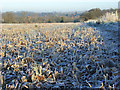
Farmland, Ewelme
Frosty stubble alongside the footpath heading towards the village from Rabbits Hill.
Image: © Andrew Smith
Taken: 7 Dec 2008
0.21 miles
10
Path Outside the Fence
The map shows the public right of way as going along a road on the RAF Benson site. This isn't right. The path runs along a narrow fenced corridor outside the perimeter fence.
There is no access onto the MOD site.
Image: © Des Blenkinsopp
Taken: 2 Dec 2011
0.22 miles