IMAGES TAKEN NEAR TO
Church Lane, WALLINGFORD, OX10 6BQ
Introduction
This page details the photographs taken nearby to Church Lane, OX10 6BQ by members of the Geograph project.
The Geograph project started in 2005 with the aim of publishing, organising and preserving representative images for every square kilometre of Great Britain, Ireland and the Isle of Man.

There are currently over 7.5m images from over14,400 individuals and you can help contribute to the project by visiting https://www.geograph.org.uk
Image Map
Images are licensed for reuse under creativecommons.org/licenses/by-sa/2.0
Notes
- Clicking on the map will re-center to the selected point.
- The higher the marker number, the further away the image location is from the centre of the postcode.
Image Listing (149 Images Found)
Images are licensed for reuse under creativecommons.org/licenses/by-sa/2.0
Image
Details
Distance
1
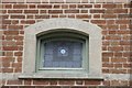
Date stone on the Window
The frame of the former school house is used as the date stone showing the place was erected in 1864
Image: © Bill Nicholls
Taken: 16 Nov 2013
0.01 miles
2
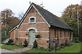
The Old School
On the corner of church lane is the old school house in North Stoke
Image: © Bill Nicholls
Taken: 16 Nov 2013
0.01 miles
3
Church Lane, North Stoke, Oxfordshire
Image: © nick macneill
Taken: 22 Apr 2010
0.01 miles
4
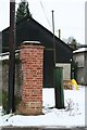
Fuel pump in the farm yard
Looks like a fuel pump so must be to dispense diesel for the tractors.
Image: © Bill Nicholls
Taken: 8 Feb 2009
0.01 miles
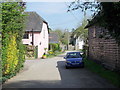
5
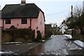
Pink house in the lane
Looking back down Church Lane towards the High Street.
Image: © Bill Nicholls
Taken: 8 Feb 2009
0.02 miles
6
The Ridgeway in North Stoke
Part of the riverside bit of the Ridgeway between Wallingford and Goring which links the Chiltern and the Downs sections of the long distance path.
Image: © Des Blenkinsopp
Taken: 8 May 2020
0.02 miles
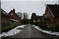
7
Church Lane, North Stoke
This quiet lane has been adapted by the Ridgeway National Trail.
Image: © Chris Heaton
Taken: 2 Oct 2007
0.02 miles
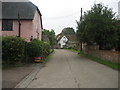
8
Church Lane
Looking up Church Lane, North Stoke.
Image: © Bill Nicholls
Taken: 8 Feb 2009
0.02 miles
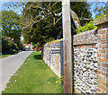
9
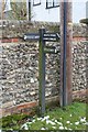
South Stoke 2.2 miles
Wooden sign post showing the Ridgeway and the number of miles to South Stoke.
Image: © Bill Nicholls
Taken: 8 Feb 2009
0.02 miles
10
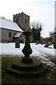
Sundial at the church
Sundial at North Stoke church, an unusual war memorial.
Image: © Bill Nicholls
Taken: 8 Feb 2009
0.03 miles