IMAGES TAKEN NEAR TO
Ipsden, WALLINGFORD, OX10 6AN
Introduction
This page details the photographs taken nearby to OX10 6AN by members of the Geograph project.
The Geograph project started in 2005 with the aim of publishing, organising and preserving representative images for every square kilometre of Great Britain, Ireland and the Isle of Man.

There are currently over 7.5m images from over14,400 individuals and you can help contribute to the project by visiting https://www.geograph.org.uk
Image Map (Loading...)


Getting Data...Please wait
Leaflet Map data © OpenStreetMap
Images are licensed for reuse under creativecommons.org/licenses/by-sa/2.0
Notes
- Clicking on the map will re-center to the selected point.
- The higher the marker number, the further away the image location is from the centre of the postcode.
Image Listing (14 Images Found)
Images are licensed for reuse under creativecommons.org/licenses/by-sa/2.0
Image
Details
Distance
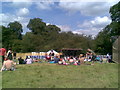
2
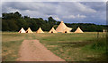
Tents at Braziers Park
Tents remaining on the festival site after the Wood Festival as featured in Image
Image: © Des Blenkinsopp
Taken: 8 Jun 2011
0.05 miles
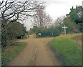
3
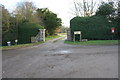
Entrance to Braziers Park
There is an OS benchmark Image on the wall end pier left of the left hand gatepost
Image: © Roger Templeman
Taken: 11 Jan 2017
0.07 miles
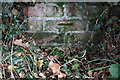
4
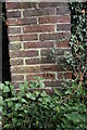
Benchmark on wall at entrance to Braziers Park
Ordnance Survey cut mark benchmark described on the Bench Mark Database at http://www.bench-marks.org.uk/bm37470
Image: © Roger Templeman
Taken: 4 Apr 2011
0.07 miles
5
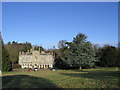
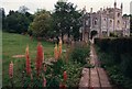
Braziers Park
Braziers Park runs short courses and is also home to a resident community. From their website ( http://www.braziers.org.uk/ ):
"Braziers Park is a community, a residential college and an architectural treasure hidden deep in the south Oxfordshire countryside in an Area of Outstanding Natural Beauty. It was founded in 1950 as an educational trust, and is a continuing experiment in the advantages and problems of living in a group. Community members share responsibility for running the mansion house (a Grade II* listed building), 55 acres of land, organic kitchen garden and livestock, facilitating courses and organising events assisted by visiting volunteers from around the world."
Image: © HelenK
Taken: 2 Jan 2010
0.08 miles
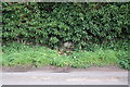
7
Benchmark on roadside wall near Braziers Park
Ordnance Survey cut mark benchmark described on the Bench Mark Database at http://www.bench-marks.org.uk/bm37474
Image: © Roger Templeman
Taken: 4 Apr 2011
0.11 miles
8
Ivy-covered flint and brick wall on western boundary of Braziers Park
There is an OS benchmark Image on bricks in the wall where the ivy has been cleared
Image: © Roger Templeman
Taken: 4 Apr 2011
0.11 miles
10
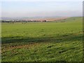
Farmland, Ipsden
A view across the Thames valley towards the Berkshire Downs from beside the road at Braziers Park. Beyond this large field you can just make out traffic on the A4074.
Image: © Andrew Smith
Taken: 8 Feb 2008
0.18 miles