IMAGES TAKEN NEAR TO
Datchet Green, WALLINGFORD, OX10 0QB
Introduction
This page details the photographs taken nearby to Datchet Green, OX10 0QB by members of the Geograph project.
The Geograph project started in 2005 with the aim of publishing, organising and preserving representative images for every square kilometre of Great Britain, Ireland and the Isle of Man.

There are currently over 7.5m images from over14,400 individuals and you can help contribute to the project by visiting https://www.geograph.org.uk
Image Map (Loading...)


Getting Data...Please wait
Leaflet Map data © OpenStreetMap
Images are licensed for reuse under creativecommons.org/licenses/by-sa/2.0
Notes
- Clicking on the map will re-center to the selected point.
- The higher the marker number, the further away the image location is from the centre of the postcode.
Image Listing (104 Images Found)
Images are licensed for reuse under creativecommons.org/licenses/by-sa/2.0
Image
Details
Distance
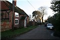
1
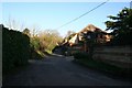
Bakers Lane
Bakers Lane which leads round to Bell Lane, Brightwell-cum-Sotwell.
Image: © Bill Nicholls
Taken: 1 Jan 2010
0.09 miles
2
Penny Green Lane
Should be Penny Green Lane that will take you back to Sotwell Street.
Image: © Bill Nicholls
Taken: 1 Jan 2010
0.10 miles
3
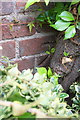
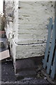
Benchmark on Spring Cottage
Ordnance Survey cut mark described on the Bench Mark Database at http://www.bench-marks.org.uk/bm23115
Image: © Roger Templeman
Taken: 2 Sep 2015
0.11 miles
4
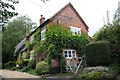
Spring Cottage, Wellsprings
There is an OS benchmark Image hidden behind the climbing plant on the near corner of the house, left hand face
Image: © Roger Templeman
Taken: 2 Sep 2015
0.11 miles
5
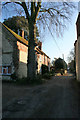
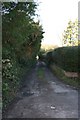
Tree on Bakers Lane
Looking further down Bakers Lane just up from a church I'm visiting.
Image: © Bill Nicholls
Taken: 1 Jan 2010
0.11 miles
6
Benchmark on Bell Cottage, High Road
The Ordnance Survey cut mark benchmark is described on the Bench Mark Database at http://www.bench-marks.org.uk/bm23114
Image: © Roger Templeman
Taken: 15 Mar 2012
0.11 miles
7
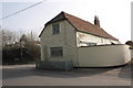
House at junction of High Road and Bell Lane
There is an OS benchmark Image on the front face of the house to the left of the trellis
Image: © Roger Templeman
Taken: 15 Mar 2012
0.12 miles
8
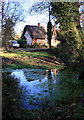
Snail Cottage and the Wellsprings
One of a series of springs along here at the foot of the Sinodun Hills, this is one of several sources of the Mackney Brook, a disorganized sort of stream which makes its way via a series of diversions and side channels into the Mill Brook, eventually reaching the Thames at Wallingford.
Image: © Des Blenkinsopp
Taken: 8 Dec 2011
0.12 miles
9
Bakers Lane
Bakers Lane leading to Slade End, part of Brightwell-cum-Sotwell.
Image: © Bill Nicholls
Taken: 1 Jan 2010
0.12 miles
10
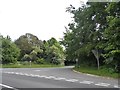
High Road, Brightwell-cum-Sotwell
This is the road to the village from the small bypass
Image: © David Howard
Taken: 29 May 2016
0.13 miles