IMAGES TAKEN NEAR TO
Chiltern Crescent, WALLINGFORD, OX10 0PE
Introduction
This page details the photographs taken nearby to Chiltern Crescent, OX10 0PE by members of the Geograph project.
The Geograph project started in 2005 with the aim of publishing, organising and preserving representative images for every square kilometre of Great Britain, Ireland and the Isle of Man.

There are currently over 7.5m images from over14,400 individuals and you can help contribute to the project by visiting https://www.geograph.org.uk
Image Map (Loading...)


Getting Data...Please wait
Leaflet Map data © OpenStreetMap
Images are licensed for reuse under creativecommons.org/licenses/by-sa/2.0
Notes
- Clicking on the map will re-center to the selected point.
- The higher the marker number, the further away the image location is from the centre of the postcode.
Image Listing (37 Images Found)
Images are licensed for reuse under creativecommons.org/licenses/by-sa/2.0
Image
Details
Distance
1
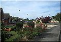
Red Kites in Chiltern Crescent
Red Kites are now seriously suburban.
These large birds of prey were reintroduced into the Chilterns having not been seen for very many years.
They have established successfully and are numerous all across the area but now have a boldness not usually associated with this sort of species. It's quite normal in Wallingford to see groups of a dozen or more circling low over houses and gardens, as in this picture.
They are especially fond of this part of town, where they are obviously getting fed. The Nature people keep saying not to do this because kitchen waste isn't good for wild creatures, but I suspect it's an uphill struggle given the attraction of having these great things on your bird table rather than starlings and pigeons.
So, bird watchers, no need to head for the hills to see Red Kites. Suburban Wallingford's the place.
Image: © Des Blenkinsopp
Taken: 14 Jun 2011
0.02 miles
2
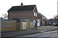
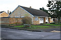
Fir Tree Avenue, houses and electricity substation
There is an OS benchmark Image on the corner of the electricity substation enclosure
Image: © Roger Templeman
Taken: 21 Jan 2014
0.06 miles
3
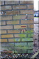
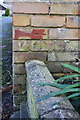
Benchmark on electricity substation, Fir Tree Avenue
Ordnance Survey cut mark benchmark described on the Bench Mark Database at http://www.bench-marks.org.uk/bm25842
Image: © Roger Templeman
Taken: 21 Jan 2014
0.06 miles
4
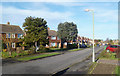
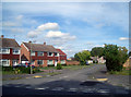
Along Greenfield Crescent
The houses are set at a slight angle to the street giving a less linear effect than in many suburban roads.
Image: © Des Blenkinsopp
Taken: 28 Dec 2013
0.11 miles
5
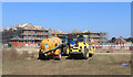
Building Site, Wallingford
An as yet nameless street of houses going up on land between town and the by pass.
Image: © Des Blenkinsopp
Taken: 7 Sep 2021
0.13 miles
6
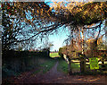
Say No To Site B
This edge of town footpath emerges from behind the houses onto the locally controversial "Site B", an area of green fields inside the Wallingford by-pass.
Property speculators want to build about four million houses all over it, but everyone else prefers it as it is.
Cue for a row......
Image: © Des Blenkinsopp
Taken: 9 Dec 2011
0.14 miles
7
Greenfield Crescent, Wallingford
This newish part of town is favoured by Red Kites. There are two just visible top right.
See also Image
Image: © Des Blenkinsopp
Taken: 14 Jun 2011
0.15 miles
8
Benchmark on wall of Greenfield Crescent
Ordnance Survey cut mark benchmark described on the Bench Mark Database at http://www.bench-marks.org.uk/bm25841
Image: © Roger Templeman
Taken: 21 Jan 2014
0.16 miles
9
Greenfield Crescent and #67 Fir Tree Avenue
There is an OS benchmark Image on the corner of the boundary wall above the flower bed
Image: © Roger Templeman
Taken: 21 Jan 2014
0.16 miles
10
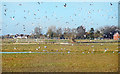
Birds on the Building Site
The builders came here about a year ago, cut a load of trees down to impress the neighbours and haven't been seen since.
A lake has formed in the middle which has proved a big hit with local seagulls.
Image: © Des Blenkinsopp
Taken: 24 Feb 2019
0.16 miles