IMAGES TAKEN NEAR TO
Wantage Road, WALLINGFORD, OX10 0LR
Introduction
This page details the photographs taken nearby to Wantage Road, OX10 0LR by members of the Geograph project.
The Geograph project started in 2005 with the aim of publishing, organising and preserving representative images for every square kilometre of Great Britain, Ireland and the Isle of Man.

There are currently over 7.5m images from over14,400 individuals and you can help contribute to the project by visiting https://www.geograph.org.uk
Image Map
Images are licensed for reuse under creativecommons.org/licenses/by-sa/2.0
Notes
- Clicking on the map will re-center to the selected point.
- The higher the marker number, the further away the image location is from the centre of the postcode.
Image Listing (48 Images Found)
Images are licensed for reuse under creativecommons.org/licenses/by-sa/2.0
Image
Details
Distance
1
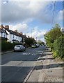
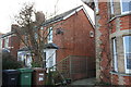
Wallingford: Wantage Road
With residential ribbon development.
Image: © Stefan Czapski
Taken: 15 Oct 2019
0.01 miles
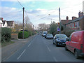
2
Station Road, Wallingford
The station is now on the Cholsey-Wallingford railway which I can highly recommend.
Image: © David Howard
Taken: 26 Oct 2019
0.02 miles
4
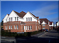
Blue Mountains
Formerly part of a large hospital site, this area has been redeveloped as housing. The nearest building is an original part of the hospital complex, the rest is modern.
The builders have had a good stab at following the older style, but the clever criss-cross brickwork was obviously a bit much.
Image: © Des Blenkinsopp
Taken: 24 Jan 2010
0.04 miles
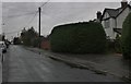
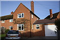
5
Houses on Wantage Road
There is an OS benchmark Image on the front of the middle house on its near corner
Image: © Roger Templeman
Taken: 20 Dec 2013
0.05 miles
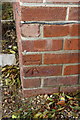
6

Benchmark on #49 Wantage Road
Ordnance Survey cut mark benchmark described on the Bench Mark Database at http://www.bench-marks.org.uk/bm23117
Image: © Roger Templeman
Taken: 20 Dec 2013
0.05 miles
7
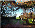
Say No To Site B
This edge of town footpath emerges from behind the houses onto the locally controversial "Site B", an area of green fields inside the Wallingford by-pass.
Property speculators want to build about four million houses all over it, but everyone else prefers it as it is.
Cue for a row......
Image: © Des Blenkinsopp
Taken: 9 Dec 2011
0.08 miles
8
#3 Sinodun Road
There is an OS benchmark Image on the near corner of the house left of the black downpipe
Image: © Roger Templeman
Taken: 20 Dec 2013
0.09 miles
9
Benchmark on #3 Sinodun Road
Ordnance Survey cut mark benchmark described on the Bench Mark Database at http://www.bench-marks.org.uk/bm26028
Image: © Roger Templeman
Taken: 20 Dec 2013
0.09 miles
10

Says it all
I think the plaque says everything. Image
Image: © Bill Nicholls
Taken: 1 Mar 2008
0.12 miles