IMAGES TAKEN NEAR TO
Sheridan Way, OLDHAM, OL9 9UY
Introduction
This page details the photographs taken nearby to Sheridan Way, OL9 9UY by members of the Geograph project.
The Geograph project started in 2005 with the aim of publishing, organising and preserving representative images for every square kilometre of Great Britain, Ireland and the Isle of Man.

There are currently over 7.5m images from over14,400 individuals and you can help contribute to the project by visiting https://www.geograph.org.uk
Image Map
Images are licensed for reuse under creativecommons.org/licenses/by-sa/2.0
Notes
- Clicking on the map will re-center to the selected point.
- The higher the marker number, the further away the image location is from the centre of the postcode.
Image Listing (9 Images Found)
Images are licensed for reuse under creativecommons.org/licenses/by-sa/2.0
Image
Details
Distance
5
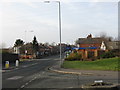
Chadderton - Middleton Road
Taken from the junction with Nordens Road.
Image: © Peter Whatley
Taken: 21 Jan 2010
0.19 miles
7
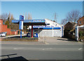
Petrol filling station, Chadderton
This filling station has been closed for some time. It is on Middleton Road.
Image: © michael ely
Taken: 18 Mar 2011
0.24 miles
8
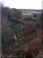
Wince Brook, Chadderton
Looking in a southwesterly direction down the valley carved by Wince Brook, a tributary of the River Irk.
Image: © Keith Williamson
Taken: 24 Nov 2005
0.25 miles
9
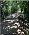
Old Railway Trackbed
Now a cycleway and path off Ferney Field Road
Image: © Kevin Waterhouse
Taken: 10 Aug 2021
0.25 miles