IMAGES TAKEN NEAR TO
Pinewood, OLDHAM, OL9 9TS
Introduction
This page details the photographs taken nearby to Pinewood, OL9 9TS by members of the Geograph project.
The Geograph project started in 2005 with the aim of publishing, organising and preserving representative images for every square kilometre of Great Britain, Ireland and the Isle of Man.

There are currently over 7.5m images from over14,400 individuals and you can help contribute to the project by visiting https://www.geograph.org.uk
Image Map
Images are licensed for reuse under creativecommons.org/licenses/by-sa/2.0
Notes
- Clicking on the map will re-center to the selected point.
- The higher the marker number, the further away the image location is from the centre of the postcode.
Image Listing (10 Images Found)
Images are licensed for reuse under creativecommons.org/licenses/by-sa/2.0
Image
Details
Distance
1
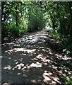
Old Railway Trackbed
Now a cycleway and path off Ferney Field Road
Image: © Kevin Waterhouse
Taken: 10 Aug 2021
0.13 miles
2
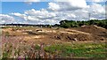
Major Earth Remediation Works
View from the old railway trackbed to Middleton Junction
Image: © Kevin Waterhouse
Taken: 10 Aug 2021
0.16 miles
3
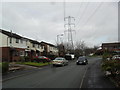
Redwood
1980s houses in Chadderton Park.
Image: © Burgess Von Thunen
Taken: 4 Feb 2013
0.21 miles
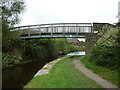
4
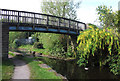
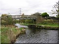
Footbridge over the Rochdale Canal
Bridge 75 near Middleton Junction
Image: © michael ely
Taken: 16 May 2014
0.22 miles
5

Cows at Foxdenton
The area is a small rural enclave between Middleton and Chadderton.
Image: © Bill Boaden
Taken: 22 Jul 2013
0.22 miles
7
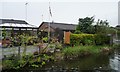
Flying the flag along Violet Way, Chadderton
Seen from a passing narrowboat on the Rochdale Canal.
Image: © Christine Johnstone
Taken: 8 May 2014
0.24 miles
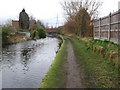
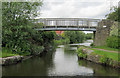
9
Rochdale Canal
The Rochdale Canal near Middleton Junction.
Image: © Keith Williamson
Taken: 11 Nov 2005
0.24 miles