IMAGES TAKEN NEAR TO
St. Georges Square, OLDHAM, OL9 9NX
Introduction
This page details the photographs taken nearby to St. Georges Square, OL9 9NX by members of the Geograph project.
The Geograph project started in 2005 with the aim of publishing, organising and preserving representative images for every square kilometre of Great Britain, Ireland and the Isle of Man.

There are currently over 7.5m images from over14,400 individuals and you can help contribute to the project by visiting https://www.geograph.org.uk
Image Map
Images are licensed for reuse under creativecommons.org/licenses/by-sa/2.0
Notes
- Clicking on the map will re-center to the selected point.
- The higher the marker number, the further away the image location is from the centre of the postcode.
Image Listing (36 Images Found)
Images are licensed for reuse under creativecommons.org/licenses/by-sa/2.0
Image
Details
Distance
1
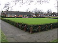
Bowling Green, St. George's Square, Chadderton
Provided as part of a planned estate of housing for the elderly over 50 years ago.
Image: © Peter Whatley
Taken: 20 Jan 2010
0.09 miles
2
585 & 587 Broadway, Chadderton - 50 Years On
Fifty years on from an earlier photograph http://www.geograph.org.uk/photo/1083455 the two houses exhibit many signs of the intervening years' cultural and societal changes. Double-glazed windows and porches have become standard and in white - a colour unthinkable in the coal-fired 1960s. Television aerials sprout from the chimneys in multiple, but some chimneys have clearly been capped or adapted to take a gas flue, with coal fires replaced by gas central heating. The gas supply pipe for 585 is visible near the front door. Alarms and security lights also feature, reflecting modern concerns. Broadway is now far too busy to permit daytime parking, but several "wheelie" and recycling bins obstruct the pavement.
Image: © Peter Whatley
Taken: 20 Jan 2010
0.10 miles
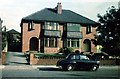
3
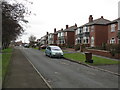
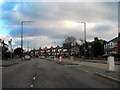
Semis In St. George's Square, Chadderton
Image: © Peter Whatley
Taken: 20 Jan 2010
0.10 miles
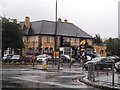
4
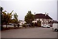
The Whitegate public house
Built in 1930s "road house" style, this large pub dominates the junction between Broadway and Hollinwood Avenue. Until the 1970s, a grass bowling green existed to the left of the row of trees in the picture. As is evident, it was removed to provide extra car parking. During the 1990s, the pub's owners had a motel block built with its frontage roughly where the trees are in the photo.
Image: © Peter Whatley
Taken: Unknown
0.10 miles
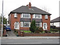
5
585 & 587 Broadway, Chadderton
Classic pre-war semis built around 1938/39 on what was then still a new road, Broadway having been completed in the late 1920s. No road markings are present, since the rarity of private motoring in 1960 meant that parking on the main carriageway was of no issue. All the houses on this part of Broadway were built massively, featuring Accrington brick (so dense that even modern drills have difficulty piercing a hole) and roof timbers of size and quality unobtainable (and unaffordable) post-WW2. The two houses' paint schemes are absolutely typical of the late 1950s and early 1960s. Brown for one, eau-de-nil (aka puke green!) for the other. Both calculated to minimise the visible impact of pervasive pollution from a coal-based economy, including, of course, domestic coal fires. Central heating was 5-10 years in the future for most families.
For a 2010 update picture, see http://www.geograph.org.uk/photo/1675903
Image: © Whatlep
Taken: Unknown
0.10 miles
7
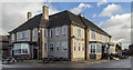
Whitegate Inn
The Whitegate Inn public house on the corner of Broadway and Hollinwood Avenue.
Image: © Peter McDermott
Taken: 13 Nov 2015
0.11 miles
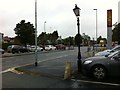
10
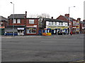
Local shops - Broadway at Moston Lane East (south west corner)
All four corners of the junction between the two roads were provided with shops as part of the design when Broadway was built in the late 1920s. In the 1960s, "Incredible Edibles" was a greengrocer's shop, while what appears to be an ordinary terraced house behind the post box was really New Moston post office. The latter was moved to Hollinwood Avenue in the 1980s.
Image: © Peter Whatley
Taken: 19 Jan 2011
0.14 miles