IMAGES TAKEN NEAR TO
Westwood Industrial Estate, Arkwright Street, OLDHAM, OL9 9LZ
Introduction
This page details the photographs taken nearby to Westwood Industrial Estate, Arkwright Street, OL9 9LZ by members of the Geograph project.
The Geograph project started in 2005 with the aim of publishing, organising and preserving representative images for every square kilometre of Great Britain, Ireland and the Isle of Man.

There are currently over 7.5m images from over14,400 individuals and you can help contribute to the project by visiting https://www.geograph.org.uk
Image Map
Images are licensed for reuse under creativecommons.org/licenses/by-sa/2.0
Notes
- Clicking on the map will re-center to the selected point.
- The higher the marker number, the further away the image location is from the centre of the postcode.
Image Listing (49 Images Found)
Images are licensed for reuse under creativecommons.org/licenses/by-sa/2.0
Image
Details
Distance
1
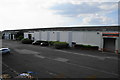
Part of Westwood Industrial Estate
A large area of industrial premises which have been reused in smaller units.
Image: © Bill Boaden
Taken: 17 Jul 2014
0.02 miles
2
Featherstall Road South (A6048)
Looking towards Royton from outside the BP petrol filling station.
Image: © michael ely
Taken: 18 Mar 2011
0.11 miles
3
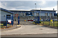
Waste processing depot on Arkwright Street
Oldham MBC is the lead authority in Greater Manchester for waste, and hosts the Greater Manchester Waste Disposal Authority.
Image: © Bill Boaden
Taken: 17 Jul 2014
0.12 miles
4

Tram Leaving Westwood
Metrolink tram 3012 leaves Westwood tram stop and heads towards Freehold along the section of track parallel to Featherstall Road South.
Image: © David Dixon
Taken: 28 Jan 2014
0.13 miles
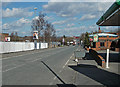
5
West Street, Chadderton
Part of a commercial area.
Image: © Bill Boaden
Taken: 17 Jul 2014
0.13 miles
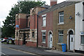
6

Firwood Church
An independent church meeting in a former Moravian church.
Image: © Bill Boaden
Taken: 17 Jul 2014
0.13 miles
7
Moravian Sunday School
Built 1906, architect C.T.Taylor, in distinctive Art Nouveau style, using terracotta decoration. Now used as business premises although at the time of the photograph it was to let. Listed Grade II. See also http://www.geograph.org.uk/photo/1947892 .
Image: © Alan Murray-Rust
Taken: 29 Jun 2010
0.13 miles
8
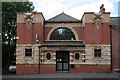
Moravian Sunday School
Full frontal view, showing the decoration to best advantage. See also http://www.geograph.org.uk/photo/1947887
Image: © Alan Murray-Rust
Taken: 29 Jun 2010
0.13 miles
9
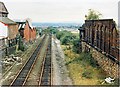
Werneth Junction 1988
Looking down the line of the original railway route into Oldham which featured the steepest gradient on a main line railway in the UK. The remaining tracks are the later route to Oldham via Hollinwood. On the right is part of Platt Brothers' derelict mill complex at Werneth.
Image: © Peter Whatley
Taken: 8 Oct 1988
0.13 miles
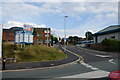
10

A669 Middleton Road nears Lansdown Road
Image: © Colin Pyle
Taken: 19 Nov 2017
0.13 miles