IMAGES TAKEN NEAR TO
Denton Lane, OLDHAM, OL9 8QD
Introduction
This page details the photographs taken nearby to Denton Lane, OL9 8QD by members of the Geograph project.
The Geograph project started in 2005 with the aim of publishing, organising and preserving representative images for every square kilometre of Great Britain, Ireland and the Isle of Man.

There are currently over 7.5m images from over14,400 individuals and you can help contribute to the project by visiting https://www.geograph.org.uk
Image Map
Images are licensed for reuse under creativecommons.org/licenses/by-sa/2.0
Notes
- Clicking on the map will re-center to the selected point.
- The higher the marker number, the further away the image location is from the centre of the postcode.
Image Listing (73 Images Found)
Images are licensed for reuse under creativecommons.org/licenses/by-sa/2.0
Image
Details
Distance
1
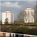
Lansdowne and Stockfield
Tower blocks in the Cowhill area of Oldham, seen from Freehold Metrolink Station which allows a view over the top of neighbouring houses.
Image: © Alan Murray-Rust
Taken: 7 Jan 2014
0.07 miles
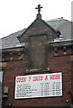
2
Former Cooperative store
On Block Lane. The dormer gable simply surrounds a stone panel with the Society name http://www.geograph.org.uk/photo/1947821 .
Image: © Alan Murray-Rust
Taken: 29 Jun 2010
0.07 miles
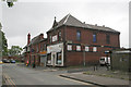
3
Oldham Industrial Cooperative Society Ld
Open 7 days a week, but no longer part of the Cooperative movement. It's a motor spares business.
Image: © Alan Murray-Rust
Taken: 29 Jun 2010
0.07 miles
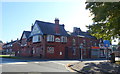
5
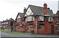
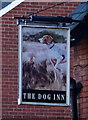
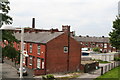
The Dog Inn, Chadderton
A fine late Victorian red-brick pub on the corner of Lansdowne Road and Block Lane.
Image: © Alan Murray-Rust
Taken: 29 Jun 2010
0.08 miles
8
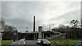
Freehold Metrolink Station
Robinson Street seems to be the car park for the station. Hartford Mill chimney is beyond the station standing alone since the mill is demolished.
Image: © Kevin Waterhouse
Taken: 17 Feb 2023
0.09 miles
9
Freehold: view from tram stop
Agnes Street is in the foreground, with the derelict Chadderton Mill behind.
Image: © Dr Neil Clifton
Taken: 26 Jun 2012
0.10 miles
10
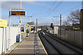
Freehold Metrolink station
Located where the former railway line runs on an embankment. The two platforms are staggered either side of the bridge over Block Lane.
Image: © Alan Murray-Rust
Taken: 7 Jan 2014
0.10 miles