IMAGES TAKEN NEAR TO
Whitegate Lane, OLDHAM, OL9 8LS
Introduction
This page details the photographs taken nearby to Whitegate Lane, OL9 8LS by members of the Geograph project.
The Geograph project started in 2005 with the aim of publishing, organising and preserving representative images for every square kilometre of Great Britain, Ireland and the Isle of Man.

There are currently over 7.5m images from over14,400 individuals and you can help contribute to the project by visiting https://www.geograph.org.uk
Image Map
Images are licensed for reuse under creativecommons.org/licenses/by-sa/2.0
Notes
- Clicking on the map will re-center to the selected point.
- The higher the marker number, the further away the image location is from the centre of the postcode.
Image Listing (46 Images Found)
Images are licensed for reuse under creativecommons.org/licenses/by-sa/2.0
Image
Details
Distance
4

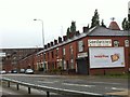
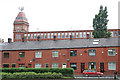
Gorse Mill From Whitegate Lane
A classic of its type, the former cotton mill is, in common with most survivors, used for retailing and light industrial uses.
Image: © Peter Whatley
Taken: 20 Jan 2010
0.11 miles

6

Millscape, Chadderton
Four mill chimneys together is no mean feat. Pity it's got little else to commend it. It's also a viewbag so I've self-moderated it to supplemental status.
Image: © Chris Allen
Taken: 6 Aug 2006
0.15 miles
8
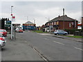
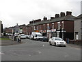
Chadderton - Foxdenton Road Local Shops
In the background is the junction with Broadway (A663).
Image: © Peter Whatley
Taken: 20 Jan 2010
0.16 miles
9

Gorse Mill
An image from 1992. The tower lacks the modern crown of antennae. The engine house is still gone and its position is marked by the cream panel on the right hand end. The blind arcading marks the position of the rope race. Urban explorers (some) seem to have problems with this structure and its original function.
Image: © Chris Allen
Taken: 7 Jun 1992
0.16 miles
10
Gorse Mill and Whitegate Lane
The two buildings show the contrast of repetitive elements applied to industrial and residential purposes.
Image: © Alan Murray-Rust
Taken: 29 Jun 2010
0.17 miles