IMAGES TAKEN NEAR TO
Slater Street, OLDHAM, OL9 6ES
Introduction
This page details the photographs taken nearby to Slater Street, OL9 6ES by members of the Geograph project.
The Geograph project started in 2005 with the aim of publishing, organising and preserving representative images for every square kilometre of Great Britain, Ireland and the Isle of Man.

There are currently over 7.5m images from over14,400 individuals and you can help contribute to the project by visiting https://www.geograph.org.uk
Image Map
Images are licensed for reuse under creativecommons.org/licenses/by-sa/2.0
Notes
- Clicking on the map will re-center to the selected point.
- The higher the marker number, the further away the image location is from the centre of the postcode.
Image Listing (57 Images Found)
Images are licensed for reuse under creativecommons.org/licenses/by-sa/2.0
Image
Details
Distance
1
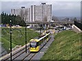
Metrolink Tram Approaching King Street
After leaving Westwood Station (Image]), the tram route passes under the A62, Oldham Way, flyover. The pedestrian underpasses at Manchester Street roundabout have been removed and replaced by a surface level footpath with signalled road and Metrolink crossings.
From the Manchester Street roundabout, the line cuts across an elevated area, previously occupied by The Pennine Way Hotel, before passing under John Street (from where this photograph was taken) to reach Image
http://www.lrta.org/Manchester/rochdale.html Manchester to Oldham and Rochdale (Light Rail Transit Association)
Image: © David Dixon
Taken: 28 Jan 2014
0.04 miles
2
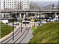
Metrolink Tramway, Oldham Way Flyover and Manchester Square Roundabout
The new Metrolink line into Oldham passes under the A62 (Oldham Way) flyover. The pedestrian underpasses at Manchester Street roundabout have been removed and replaced by a surface level footpath with signalled road and Metrolink crossings.
http://www.lrta.org/Manchester/rochdale.html Manchester to Oldham and Rochdale (Light Rail Transit Association)
Image: © David Dixon
Taken: 28 Jan 2014
0.06 miles
3
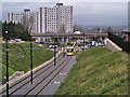
Metrolink Into Oldham
After leaving Westwood Station (Image]), the tram route passes under the A62, Oldham Way, flyover. The pedestrian underpasses at Manchester Street roundabout have been removed and replaced by a surface level footpath with signalled road and Metrolink crossings.
From the Manchester Street roundabout, the line cuts across an elevated area, previously occupied by The Pennine Way Hotel, before passing under John Street from where this photograph was taken.
http://www.lrta.org/Manchester/rochdale.html Manchester to Oldham and Rochdale (Light Rail Transit Association)
Image: © David Dixon
Taken: 28 Jan 2014
0.07 miles
5
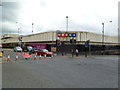
Oldham, bingo hall
Mecca Bingo, on Manchester Street. http://www.meccabingo.com/bingo-clubs/Oldham
Image: © Mike Faherty
Taken: 19 Sep 2011
0.08 miles
6
Foundry Street, Oldham
The Civic Centre, the seat of Oldham Metropolitan Borough Council, seen from Foundry Street, in Oldham, Greater Manchester.
Image: © Steven Haslington
Taken: 3 Jun 2011
0.10 miles
7
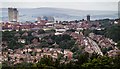
Oldham
View of Oldham seen from beneath Hartshead Pike.
Image: © Peter McDermott
Taken: 2 Jul 2017
0.11 miles
8
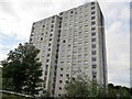
Flats on Vale Drive, Oldham
Built in the brutalist style of architecture which was in vogue in the 1950s to 1970s.
Image: © philandju
Taken: 18 Sep 2017
0.11 miles

10
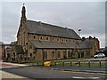
Our Lady of Mount Carmel and St Patrick's Church
This Catholic church was opened in August 1870.
Image: © David Dixon
Taken: 28 Jan 2014
0.12 miles