IMAGES TAKEN NEAR TO
Coppice Street, OLDHAM, OL8 4BL
Introduction
This page details the photographs taken nearby to Coppice Street, OL8 4BL by members of the Geograph project.
The Geograph project started in 2005 with the aim of publishing, organising and preserving representative images for every square kilometre of Great Britain, Ireland and the Isle of Man.

There are currently over 7.5m images from over14,400 individuals and you can help contribute to the project by visiting https://www.geograph.org.uk
Image Map
Images are licensed for reuse under creativecommons.org/licenses/by-sa/2.0
Notes
- Clicking on the map will re-center to the selected point.
- The higher the marker number, the further away the image location is from the centre of the postcode.
Image Listing (4 Images Found)
Images are licensed for reuse under creativecommons.org/licenses/by-sa/2.0
Image
Details
Distance
1

Werneth Primary School
On Coppice Street with its amazing clock tower
Image: © Kevin Waterhouse
Taken: 17 Mar 2023
0.03 miles
2
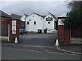
Werneth Cricket Club - Entrance
The entrance to Werneth Cricket, Bowling & Tennis Club's Coppice ground on Chamber Road.
Image: © BatAndBall
Taken: 22 Nov 2012
0.08 miles
3
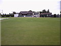
Werneth Cricket Club - Pavilion
The pavilion at Werneth CC's Coppice ground.
The changing rooms are just to the right of the pavilion. To the left of the building, behind the hedge, is a bowling green.
Image: © BatAndBall
Taken: 13 Aug 2012
0.08 miles
4
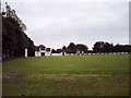
Werneth Cricket Club - Scoreboard
The scoreboard at Werneth CC.
The club have two teams in the Central Lancashire League.
Image: © BatAndBall
Taken: 13 Aug 2012
0.13 miles