IMAGES TAKEN NEAR TO
Ashton Road, OLDHAM, OL8 3HS
Introduction
This page details the photographs taken nearby to Ashton Road, OL8 3HS by members of the Geograph project.
The Geograph project started in 2005 with the aim of publishing, organising and preserving representative images for every square kilometre of Great Britain, Ireland and the Isle of Man.

There are currently over 7.5m images from over14,400 individuals and you can help contribute to the project by visiting https://www.geograph.org.uk
Image Map
Images are licensed for reuse under creativecommons.org/licenses/by-sa/2.0
Notes
- Clicking on the map will re-center to the selected point.
- The higher the marker number, the further away the image location is from the centre of the postcode.
Image Listing (22 Images Found)
Images are licensed for reuse under creativecommons.org/licenses/by-sa/2.0
Image
Details
Distance

2
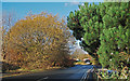
Coal Pit Lane
Looking from its junction with the A627. This narrow lane is a rat run for local traffic between Failsworth and the south of Oldham town centre.
Image: © michael ely
Taken: 18 Nov 2014
0.03 miles
4

Ashton Road
The A627 from Ashton under Lyne to Oldham between Bardsley and Hathershaw.
Image: © Gerald England
Taken: 18 Dec 2012
0.09 miles
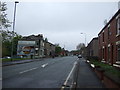
6

Ashton Road
View looking down Ashton Road in Oldham.
Image: © Peter McDermott
Taken: 2 Jul 2017
0.12 miles
7

The Half Way House
Public house on Ashton Road, half way between Oldham and Ashton.
Image: © David Dixon
Taken: 30 Jan 2010
0.14 miles

9
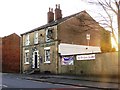
Half Way House
Public house on Ashton Road, half way between Oldham and Ashton.
Image: © David Dixon
Taken: 30 Jan 2010
0.14 miles
