IMAGES TAKEN NEAR TO
Brae Side, OLDHAM, OL8 3AP
Introduction
This page details the photographs taken nearby to Brae Side, OL8 3AP by members of the Geograph project.
The Geograph project started in 2005 with the aim of publishing, organising and preserving representative images for every square kilometre of Great Britain, Ireland and the Isle of Man.

There are currently over 7.5m images from over14,400 individuals and you can help contribute to the project by visiting https://www.geograph.org.uk
Image Map
Images are licensed for reuse under creativecommons.org/licenses/by-sa/2.0
Notes
- Clicking on the map will re-center to the selected point.
- The higher the marker number, the further away the image location is from the centre of the postcode.
Image Listing (27 Images Found)
Images are licensed for reuse under creativecommons.org/licenses/by-sa/2.0
Image
Details
Distance
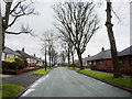
2
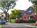
Suburban Sunshine
A postbox in the leafy Green Lane, Garden Suburbs, which skirts the boundary of Werneth Golf Club (behind the viewpoint).
Image: © Roger May
Taken: 21 Aug 2005
0.06 miles
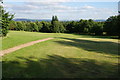
9
Copster Park
Looking towards Hollins Green.
Image: © Gerald England
Taken: 23 Mar 2010
0.17 miles
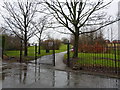
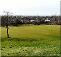
10
Open space in Copster Park
This part of the park gives views of the Pennines to the south, looking over Bardsley.
Image: © Bill Boaden
Taken: 15 Jul 2014
0.17 miles