IMAGES TAKEN NEAR TO
Limehurst Avenue, ASHTON-UNDER-LYNE, OL7 9PW
Introduction
This page details the photographs taken nearby to Limehurst Avenue, OL7 9PW by members of the Geograph project.
The Geograph project started in 2005 with the aim of publishing, organising and preserving representative images for every square kilometre of Great Britain, Ireland and the Isle of Man.

There are currently over 7.5m images from over14,400 individuals and you can help contribute to the project by visiting https://www.geograph.org.uk
Image Map (Loading...)


Getting Data...Please wait
Leaflet Map data © OpenStreetMap
Images are licensed for reuse under creativecommons.org/licenses/by-sa/2.0
Notes
- Clicking on the map will re-center to the selected point.
- The higher the marker number, the further away the image location is from the centre of the postcode.
Image Listing (15 Images Found)
Images are licensed for reuse under creativecommons.org/licenses/by-sa/2.0
Image
Details
Distance
1
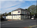
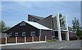
Tesco Express Store, Oldham Road - Ashton-under-Lyne
Formerly The Wellington Pub.
Image: © John Topping
Taken: 8 Oct 2012
0.03 miles
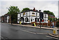
2
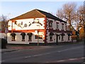
The Wellington
One of five public houses on a 700 yard stretch of Oldham Road. Not surprising that one of them has closed during the recession.
Image: © David Dixon
Taken: 30 Jan 2010
0.04 miles
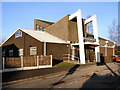
4
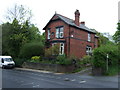
Waterloo Methodist Church
Located on Vale Street on the northern outskirts of Ashton-under Lyne.
Image: © michael ely
Taken: 12 May 2008
0.06 miles
6
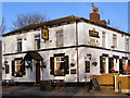
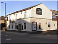
Dog and Pheasant
Public house, Oldham Road Ashton
Image: © David Dixon
Taken: 30 Jan 2010
0.10 miles
7
The Dog & Pheasant, Oldham Road
More commonly known as the Top Dog, and it has a sign to say as much. Consistently in the Good Beer Guide. Our walking group operates from here.
Image: © Bill Boaden
Taken: 29 May 2010
0.11 miles
9
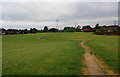
Open space between estates
This was a former tip near Timperley Clough, which has been reclaimed as open land.
Image: © Bill Boaden
Taken: 29 May 2010
0.16 miles