IMAGES TAKEN NEAR TO
Oldham Road, ASHTON-UNDER-LYNE, OL7 9ND
Introduction
This page details the photographs taken nearby to Oldham Road, OL7 9ND by members of the Geograph project.
The Geograph project started in 2005 with the aim of publishing, organising and preserving representative images for every square kilometre of Great Britain, Ireland and the Isle of Man.

There are currently over 7.5m images from over14,400 individuals and you can help contribute to the project by visiting https://www.geograph.org.uk
Image Map
Images are licensed for reuse under creativecommons.org/licenses/by-sa/2.0
Notes
- Clicking on the map will re-center to the selected point.
- The higher the marker number, the further away the image location is from the centre of the postcode.
Image Listing (28 Images Found)
Images are licensed for reuse under creativecommons.org/licenses/by-sa/2.0
Image
Details
Distance
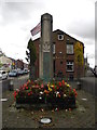
1
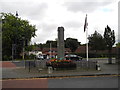
Waterloo and Taunton War Memorial - Ashton-under-Lyne
1914-1918 and 1939-1945 War Memorial.
Image: © John Topping
Taken: 6 Oct 2012
0.11 miles
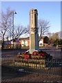
2
Waterloo and Taunton War Memorial - Ashton-under-Lyne
1914-1918 and 1939-1945 War Memorial.
Image: © John Topping
Taken: 6 Oct 2012
0.11 miles
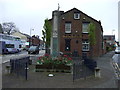
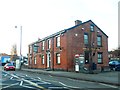
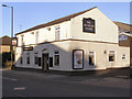
7
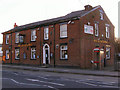
Dog and Partridge
Public house on Oldham Road
Image: © David Dixon
Taken: 30 Jan 2010
0.12 miles