IMAGES TAKEN NEAR TO
Clive Street, ASHTON-UNDER-LYNE, OL7 9ED
Introduction
This page details the photographs taken nearby to Clive Street, OL7 9ED by members of the Geograph project.
The Geograph project started in 2005 with the aim of publishing, organising and preserving representative images for every square kilometre of Great Britain, Ireland and the Isle of Man.

There are currently over 7.5m images from over14,400 individuals and you can help contribute to the project by visiting https://www.geograph.org.uk
Image Map
Images are licensed for reuse under creativecommons.org/licenses/by-sa/2.0
Notes
- Clicking on the map will re-center to the selected point.
- The higher the marker number, the further away the image location is from the centre of the postcode.
Image Listing (33 Images Found)
Images are licensed for reuse under creativecommons.org/licenses/by-sa/2.0
Image
Details
Distance
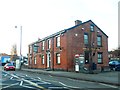
1
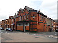
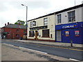
Corner of Taunton Road with Clive Street
Looks like an old Co-op building? Waterloo area of Ashton-under-Lyne.
Image: © John Topping
Taken: 13 Sep 2012
0.05 miles
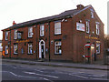
2
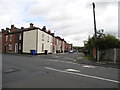
Langham Street, Ashton-under-Lyne
Waterloo area Of Ashton-under-Lyne.
Image: © John Topping
Taken: 13 Sep 2012
0.05 miles
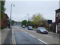
3
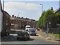
Newmarket Road
At the junction with Oldham Road.
Image: © Gerald England
Taken: 17 Aug 2016
0.08 miles
4
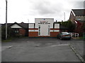
Waterloo Medical Centre - Ashton-under-Lyne
Image: © John Topping
Taken: 6 Oct 2012
0.09 miles
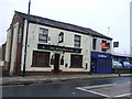
7
The Woodman
Public house, Oldham Road, Ashton.
Image: © David Dixon
Taken: 30 Jan 2010
0.11 miles
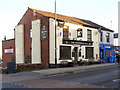
10
Dog and Partridge
Public house on Oldham Road
Image: © David Dixon
Taken: 30 Jan 2010
0.12 miles