IMAGES TAKEN NEAR TO
Sharon Close, ASHTON-UNDER-LYNE, OL7 0DW
Introduction
This page details the photographs taken nearby to Sharon Close, OL7 0DW by members of the Geograph project.
The Geograph project started in 2005 with the aim of publishing, organising and preserving representative images for every square kilometre of Great Britain, Ireland and the Isle of Man.

There are currently over 7.5m images from over14,400 individuals and you can help contribute to the project by visiting https://www.geograph.org.uk
Image Map
Images are licensed for reuse under creativecommons.org/licenses/by-sa/2.0
Notes
- Clicking on the map will re-center to the selected point.
- The higher the marker number, the further away the image location is from the centre of the postcode.
Image Listing (58 Images Found)
Images are licensed for reuse under creativecommons.org/licenses/by-sa/2.0
Image
Details
Distance
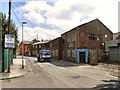
1
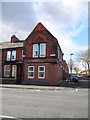
End Terrace, Birch Street/Pelham Street
Corner terrace was formerly a butcher's shop.
Image: © John Topping
Taken: 13 Mar 2013
0.07 miles
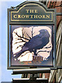
3
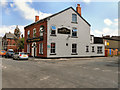
The Crowthorn
Public house at the corner of Crowthorn Road and Ryecroft Street, Ashton-Under-Lyne.
Image: © David Dixon
Taken: 4 Jun 2011
0.07 miles
4
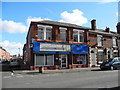
Convenience Store, Birch Street
Formerly a Co-op store.
Image: © John Topping
Taken: 13 Mar 2013
0.08 miles
6
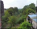
Abandoned Railway Track
From the old Slate Lane bridge, showing the track of the long abandoned Northern loop line from Guide Bridge.
Image: © Gerald England
Taken: 30 Jun 2009
0.16 miles
7
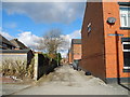
Alley way off Marlborough Street
Alley way connecting Marlborough Street with Trafalgar Street, Mansfield Street and Pelham Street.
Image: © John Topping
Taken: 13 Mar 2013
0.16 miles
8
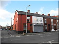
Birch Superstore, Birch Street/Ashton-under-Lyne
Formerly a Bakery shop.
Image: © John Topping
Taken: 13 Mar 2013
0.17 miles
9
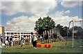
Oakdale Sports Day
Sports day at Oakdale School. The school off Manchester Road on Ashton Moss was a primary/junior school for pupils with Special Needs. It was demolished to make way for the M60 motorway.
Image: © Gerald England
Taken: Unknown
0.17 miles
10

End of Slate Lane
The corner of Pelham Street and South Street from the end of Slate Lane.
Image: © Gerald England
Taken: 30 Jun 2009
0.17 miles