IMAGES TAKEN NEAR TO
Egerton Street, ASHTON-UNDER-LYNE, OL6 9NZ
Introduction
This page details the photographs taken nearby to Egerton Street, OL6 9NZ by members of the Geograph project.
The Geograph project started in 2005 with the aim of publishing, organising and preserving representative images for every square kilometre of Great Britain, Ireland and the Isle of Man.

There are currently over 7.5m images from over14,400 individuals and you can help contribute to the project by visiting https://www.geograph.org.uk
Image Map (Loading...)


Getting Data...Please wait
Leaflet Map data © OpenStreetMap
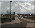
Images are licensed for reuse under creativecommons.org/licenses/by-sa/2.0
Notes
- Clicking on the map will re-center to the selected point.
- The higher the marker number, the further away the image location is from the centre of the postcode.
Image Listing (126 Images Found)
Images are licensed for reuse under creativecommons.org/licenses/by-sa/2.0
Image
Details
Distance
1
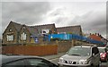
St James C of E Primary School
On Romney Street.
Image: © Gerald England
Taken: 10 May 2012
0.05 miles
2
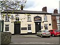
Free House on Albermarle Street
A house was built on this site in 1847. It was granted a beer licence in 1867 and a full licence in 1880. It was then known as the "Corporation" but in recent years it became the "Albermarle". Now it is the "New Sulivans Free House".
Image: © Gerald England
Taken: 10 May 2012
0.07 miles
4
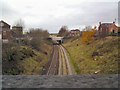
Stalybridge to Victoria line
The railway line from Stalybridge to Manchester Victoria from the Romney Street bridge. The next bridge in view is Cowhill Lane.
Image: © Gerald England
Taken: 19 Nov 2009
0.08 miles
5
Romney Street Bridge
The bridge over the Stalybridge to Manchester Victoria railway line is now for pedestrians only. The section from the bridge to Penny Meadow has been utilised for the construction of the Northern Relief Road Image
Image: © Gerald England
Taken: 10 May 2012
0.09 miles
6
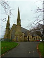
St James Church, Ashton-Under-Lyne
Image: © Alexander P Kapp
Taken: 20 Nov 2012
0.09 miles
7
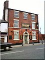
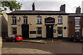
The Tontine
On the corner of Penny Meadow and Newton Street. It opened in 1837 and became a Wilson's house in 1899.
Image: © Gerald England
Taken: 19 Nov 2009
0.09 miles
8
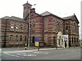
Albion Warehouse (formerly Albion School)
The foundation stone for Albion Sunday School on Penny Meadow was laid on Good Friday 1861 by Hugh Mason, who at the time was Mayor of the Borough. It was completed in 1862, opened on Good Friday of the same year and at the time was the largest Sunday School in England. The building included an assembly room that could seat over 1000 people, a lecture theatre, an infants' room and eleven classrooms. It opened as a day school in 1869 and celebrated its jubilee in 1912. The Grade II* listed building http://www.britishlistedbuildings.co.uk/en-212677-albion-warehouse- was for a carpet showroom for many years but is now an office furniture warehouse.
Image: © Gerald England
Taken: 14 Aug 2016
0.09 miles
9
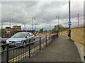
Ashton Northern Relief Road
A recently opened stretch of road bypassing Penny Meadow Image and Wellington Road Image for through traffic. The prominent building on the left is the offices of Tameside Metropolitan Borough Council.
Image: © Gerald England
Taken: 10 May 2012
0.09 miles
10
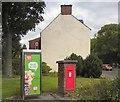
EIIR postbox (OL6 12)
Postbox next to a telephone box near the junction of Cricket's Lane and Whiteacre Road.
Image: © Gerald England
Taken: 14 Aug 2016
0.10 miles