IMAGES TAKEN NEAR TO
Hague Street, ASHTON-UNDER-LYNE, OL6 9NP
Introduction
This page details the photographs taken nearby to Hague Street, OL6 9NP by members of the Geograph project.
The Geograph project started in 2005 with the aim of publishing, organising and preserving representative images for every square kilometre of Great Britain, Ireland and the Isle of Man.

There are currently over 7.5m images from over14,400 individuals and you can help contribute to the project by visiting https://www.geograph.org.uk
Image Map (Loading...)


Getting Data...Please wait
Leaflet Map data © OpenStreetMap
Images are licensed for reuse under creativecommons.org/licenses/by-sa/2.0
Notes
- Clicking on the map will re-center to the selected point.
- The higher the marker number, the further away the image location is from the centre of the postcode.
Image Listing (37 Images Found)
Images are licensed for reuse under creativecommons.org/licenses/by-sa/2.0
Image
Details
Distance
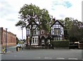
1
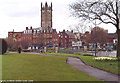
St Michaels Parish Church, Ashton under Lyne
The Parish Church of St Michael and All Angels, Ashton under Lyne, boasts some of the best examples of fifteenth century stained glass left in Britain. There are eighteen panels illustrating the life of St. Helena. For more information, see www.ashton-under-lyne.com
Image: © Martin Clark
Taken: Unknown
0.02 miles
2
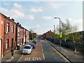
Whiteacre Road
Leading from Penny Meadow to Queens Road. Viewed from the top deck of a bus.
Image: © Gerald England
Taken: 18 Apr 2011
0.05 miles
3
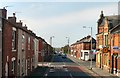
Whiteacre Road
Viewed from the top deck of a bus near Herries Street.
Image: © Gerald England
Taken: 18 Apr 2011
0.09 miles
5
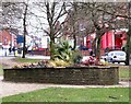
Flowerbed near Crickets Lane
Flowerbeds at Image
Image: © Gerald England
Taken: 24 Nov 2009
0.12 miles
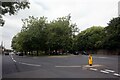
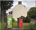
6
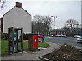
Phone box and post box
Situated on the corner of Penny Meadow (A670) and Whiteacre Road (B6194) about one kilometre northeast of Ashton's town centre.
Image: © michael ely
Taken: 31 Jan 2011
0.13 miles
7
Houses on the corner of Mossley Road and Neal Avenue
Viewed from the end of Cricket's Lane.
Image: © Gerald England
Taken: 14 Aug 2016
0.13 miles
8
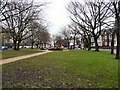
Crickets Lane Open Space
A public open space in the triangle bounded by Crickets Lane, Penny Meadow and Mossley Road.
Image: © Gerald England
Taken: 24 Nov 2009
0.13 miles
9
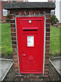
Brick-built postbox
Situated on the corner of Penny Meadow (A670) and Whiteacre Road (B6194) about one kilometre northeast of Ashton's town centre.
Image: © michael ely
Taken: 31 Jan 2011
0.13 miles
10
EIIR postbox (OL6 12)
Postbox next to a telephone box near the junction of Cricket's Lane and Whiteacre Road.
Image: © Gerald England
Taken: 14 Aug 2016
0.14 miles