IMAGES TAKEN NEAR TO
Stainmore Avenue, ASHTON-UNDER-LYNE, OL6 8XL
Introduction
This page details the photographs taken nearby to Stainmore Avenue, OL6 8XL by members of the Geograph project.
The Geograph project started in 2005 with the aim of publishing, organising and preserving representative images for every square kilometre of Great Britain, Ireland and the Isle of Man.

There are currently over 7.5m images from over14,400 individuals and you can help contribute to the project by visiting https://www.geograph.org.uk
Image Map
Images are licensed for reuse under creativecommons.org/licenses/by-sa/2.0
Notes
- Clicking on the map will re-center to the selected point.
- The higher the marker number, the further away the image location is from the centre of the postcode.
Image Listing (4 Images Found)
Images are licensed for reuse under creativecommons.org/licenses/by-sa/2.0
Image
Details
Distance
1
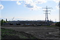
Construction of the new Ashton Academy at Broadoak
This will be a new academy constructed under the BSF scheme.
Image: © Bill Boaden
Taken: 27 May 2010
0.18 miles
2
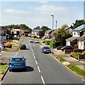
St Albans Avenue
A suburban housing estate.
Image: © Gerald England
Taken: 17 Aug 2016
0.19 miles
3
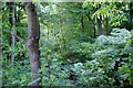
Broadoak Clough
Viewed from Lees Road. The foliage is so dense at this time of year that it is difficult to get a good vista.
Image: © Bill Boaden
Taken: 27 May 2010
0.20 miles
4
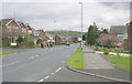
Hartshead Estate, Ashton under Lyne
Looking east along St Albans Avenue, with Hartshead Pike on the skyline.
Image: © Martin Clark
Taken: Unknown
0.23 miles