IMAGES TAKEN NEAR TO
Rowley Street, ASHTON-UNDER-LYNE, OL6 8DX
Introduction
This page details the photographs taken nearby to Rowley Street, OL6 8DX by members of the Geograph project.
The Geograph project started in 2005 with the aim of publishing, organising and preserving representative images for every square kilometre of Great Britain, Ireland and the Isle of Man.

There are currently over 7.5m images from over14,400 individuals and you can help contribute to the project by visiting https://www.geograph.org.uk
Image Map (Loading...)


Getting Data...Please wait
Leaflet Map data © OpenStreetMap
Images are licensed for reuse under creativecommons.org/licenses/by-sa/2.0
Notes
- Clicking on the map will re-center to the selected point.
- The higher the marker number, the further away the image location is from the centre of the postcode.
Image Listing (53 Images Found)
Images are licensed for reuse under creativecommons.org/licenses/by-sa/2.0
Image
Details
Distance
1
Hurst Community Centre
Hurst Community Centre on Kings Road is an independent community centre and a registered charity. The centre caters for all sections of the local community and various activities are available during the week. It has two drama groups and is fully equipped as a theatre with full lighting and sound. At the weekend, the centre is usually available for private functions with a large main hall and function room on the upper floor. http://web.archive.org/web/20100605043025/http://www.hurstcomcentre.co.uk/
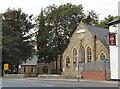
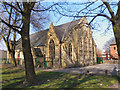
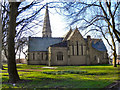
The church of St John the Evangelist was built in 1849 at an angle to the road so that it lies in a traditional west-east alignment.
Image: © Gerald England
Taken: 18 Sep 2009
0.01 miles
2
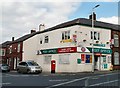
Higher Hurst Post Office
On Kings Road.
Image: © Gerald England
Taken: 18 Sep 2009
0.02 miles
3
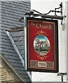
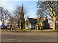
Sign for the Church
Sign of the Church at Hurst Cross Image
Image: © Gerald England
Taken: 18 Sep 2009
0.03 miles
4
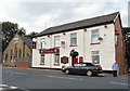
The Church
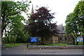
Pub near St John's Church on Kings Road at Hurst Cross. It date back to 1850. It was a Bents & Gartside's house from 1939 to 1967 when it changed to Bass. Since this photograph was taken it has been converted into a convenience store.
Image
Image: © Gerald England
Taken: 18 Sep 2009
0.03 miles
5
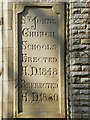
Inscription Stone
The inscription stone on Image], showing its original use as St John's Church School.
Image: © David Dixon
Taken: 2 Mar 2011
0.03 miles
6
Hurst Community Centre
The Hurst Community Centre, on Kings Road was originally built in 1848 as St John's Church School (see Image]). It is next to Image
Image: © David Dixon
Taken: 2 Mar 2011
0.03 miles
7
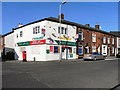
Higher Hurst Post Office And Convenience Store
The post office on King's Road, Higher Hurst.
Image: © David Dixon
Taken: 2 Mar 2011
0.04 miles
8
Church Of St John The Evangelist, Hurst
The Church Of St John the Evangelist, on King's Road, near Hurst Cross. It was built in 1849.
http://ashton-under-lyne.blogspot.com/2008/10/st-johns-hurst.html Ashton-Under-Lyne.com
Image: © David Dixon
Taken: 2 Mar 2011
0.04 miles
9
Church Of St John The Evangelist
The Church Of St John The Evangelist on King's Road near to Hurst Cross. It was Built in 1849.
http://ashton-under-lyne.blogspot.com/2008/10/st-johns-hurst.html Ashton-Under-Lyne.com
Image: © David Dixon
Taken: 2 Mar 2011
0.04 miles
10
Church of St John the Evangelist, Hurst
Image: © Bill Boaden
Taken: 27 May 2010
0.04 miles