IMAGES TAKEN NEAR TO
Sheard Avenue, ASHTON-UNDER-LYNE, OL6 8DS
Introduction
This page details the photographs taken nearby to Sheard Avenue, OL6 8DS by members of the Geograph project.
The Geograph project started in 2005 with the aim of publishing, organising and preserving representative images for every square kilometre of Great Britain, Ireland and the Isle of Man.

There are currently over 7.5m images from over14,400 individuals and you can help contribute to the project by visiting https://www.geograph.org.uk
Image Map (Loading...)


Getting Data...Please wait
Leaflet Map data © OpenStreetMap
Images are licensed for reuse under creativecommons.org/licenses/by-sa/2.0
Notes
- Clicking on the map will re-center to the selected point.
- The higher the marker number, the further away the image location is from the centre of the postcode.
Image Listing (57 Images Found)
Images are licensed for reuse under creativecommons.org/licenses/by-sa/2.0
Image
Details
Distance
1
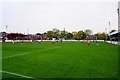
Football match at Hurst Cross
The home of Ashton United FC. The spire of St John's Church sticks up behind.
Image: © Bill Boaden
Taken: 31 Oct 2015
0.08 miles
2
Hurst Cross
The home of Ashton United AFC, reputedly the oldest semi-professional football team in Manchester. Club website: http://www.ashtonutd.com/
Image: © Gerald England
Taken: 18 Sep 2009
0.10 miles
3
The entrance to Hurst Cross football ground
The home of Ashton United FC. They currently play in the Unibond Premier Division and have been established since 1878. The building on the right is Hurst Library.
Image: © Bill Boaden
Taken: 27 May 2010
0.10 miles
4
Hurst Cross
The locality is called Hurst Cross (a small hamlet until the nineteenth century) The stone cross (Image]) at the junction of King's Road and Queen's Road is also Hurst Cross. To complicate things further, The football ground is also called Hurst Cross!
Hurst Cross football ground has been the home of Ashton United FC (formerly known as Hurst FC) since 1880 which makes it one of one of the oldest football grounds in the world.
Image: © David Dixon
Taken: 2 Mar 2011
0.11 miles
5

Junction of Broadoak Road and Smallshaw Lane, Hurst
Image: © Alexander P Kapp
Taken: 22 Nov 2011
0.11 miles
6
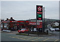
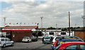
Service station on Lees Road (B6194)
At the junction with Nook Lane.
Image: © JThomas
Taken: 14 Mar 2015
0.12 miles
7
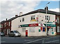
Higher Hurst Post Office
On Kings Road.
Image: © Gerald England
Taken: 18 Sep 2009
0.12 miles
8
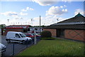
Hurst Community Centre
Hurst Community Centre on Kings Road is an independent community centre and a registered charity. The centre caters for all sections of the local community and various activities are available during the week. It has two drama groups and is fully equipped as a theatre with full lighting and sound. At the weekend, the centre is usually available for private functions with a large main hall and function room on the upper floor. http://web.archive.org/web/20100605043025/http://www.hurstcomcentre.co.uk/
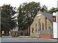
The church of St John the Evangelist was built in 1849 at an angle to the road so that it lies in a traditional west-east alignment.
Image: © Gerald England
Taken: 18 Sep 2009
0.12 miles
10
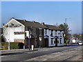
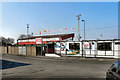
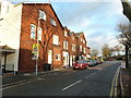
Royal Tandoori And Royal Oak
The Royal Tandoori takeaway next to the Royal Oak public house at Hurst Cross.
Image: © David Dixon
Taken: 2 Mar 2011
0.13 miles