IMAGES TAKEN NEAR TO
Durham Drive, ASHTON-UNDER-LYNE, OL6 8BP
Introduction
This page details the photographs taken nearby to Durham Drive, OL6 8BP by members of the Geograph project.
The Geograph project started in 2005 with the aim of publishing, organising and preserving representative images for every square kilometre of Great Britain, Ireland and the Isle of Man.

There are currently over 7.5m images from over14,400 individuals and you can help contribute to the project by visiting https://www.geograph.org.uk
Image Map (Loading...)


Getting Data...Please wait
Leaflet Map data © OpenStreetMap
Images are licensed for reuse under creativecommons.org/licenses/by-sa/2.0
Notes
- Clicking on the map will re-center to the selected point.
- The higher the marker number, the further away the image location is from the centre of the postcode.
Image Listing (25 Images Found)
Images are licensed for reuse under creativecommons.org/licenses/by-sa/2.0
Image
Details
Distance
1
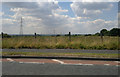
Manchester from Lees Road
Whizzing along Lees Road on my bicycle I noticed that Manchester city centre came into view.
Image: © Steven Haslington
Taken: 19 Jul 2013
0.05 miles
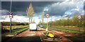
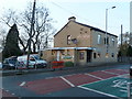
3
Bus stop and shelter on Lees Road (B6194)
Looking north.
Image: © JThomas
Taken: 14 Mar 2015
0.11 miles
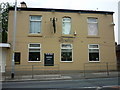
4
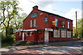
The Red House, Lees Road
Despite the signs proclaiming "open", it is most definitely shut at the moment.
Image: © Bill Boaden
Taken: 27 May 2010
0.12 miles
5
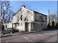
Red House, Lees Road
Image] has re-opened, but is no longer red!
Image: © David Dixon
Taken: 2 Mar 2011
0.13 miles
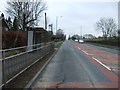
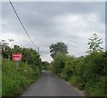
7
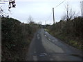
Lily Lanes
Heading north east from Lees Road (B6194), Ashton-under-Lyne.
Image: © JThomas
Taken: 14 Mar 2015
0.14 miles
10
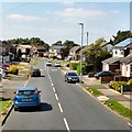
St Albans Avenue
A suburban housing estate.
Image: © Gerald England
Taken: 17 Aug 2016
0.16 miles