IMAGES TAKEN NEAR TO
Briaracre Terrace, Alt Hill, ASHTON-UNDER-LYNE, OL6 8AD
Introduction
This page details the photographs taken nearby to Briaracre Terrace, Alt Hill, OL6 8AD by members of the Geograph project.
The Geograph project started in 2005 with the aim of publishing, organising and preserving representative images for every square kilometre of Great Britain, Ireland and the Isle of Man.

There are currently over 7.5m images from over14,400 individuals and you can help contribute to the project by visiting https://www.geograph.org.uk
Image Map (Loading...)


Getting Data...Please wait
Leaflet Map data © OpenStreetMap
Images are licensed for reuse under creativecommons.org/licenses/by-sa/2.0
Notes
- Clicking on the map will re-center to the selected point.
- The higher the marker number, the further away the image location is from the centre of the postcode.
Image Listing (6 Images Found)
Images are licensed for reuse under creativecommons.org/licenses/by-sa/2.0
Image
Details
Distance
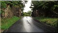
1
Former railway bridge on Alt Hill Lane west of Alt Hill
Image: © Alexander P Kapp
Taken: 22 Nov 2011
0.15 miles
2

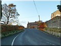
Old Rail bridge
This is one of the supports for the rail bridge just south of what was Park Bridge Station.
Image: © Stephen Darlington
Taken: 27 Aug 2015
0.15 miles
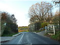
3
Alt Hill Lnae
Old railway bridge at Alt Hill Lane.
Image: © Peter McDermott
Taken: 2 Jul 2017
0.16 miles
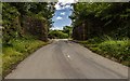
4
Railway Bridge Abutments
On Alt Hill Lane for the former Oldham and Ashton railway route
Image: © Kevin Waterhouse
Taken: 9 Sep 2022
0.16 miles